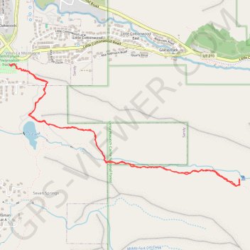
Bells Canyon Trail to Lower Falls
The Bells Canyon Trail is a stunning hike that starts by the reservoir and takes you up a steep, rocky path with beautiful views all around. Though the climb can be tough, reaching the waterfall at the top makes it totally worth the effort! #Hiking #Mountain #Lake #River #Waterfall #Forest #Nature
- Distance: 4.8 mi
- Elevation gain: 1,558 ft
- Maximum elevation: 6,778 ft
- Elevation loss: 1,558 ft
- Minimum elevation: 5,308 ft
- Moving time: 2 h 54 m
- Moving speed: 1.6 mph
- Maximum speed: 3.8 mph
- Total time: 3 h 59 m
- Global speed: 1.2 mph
Interactive trail map
Trail profile
About this trail
Name: Bells Canyon Trail to Lower Falls trail, distance, elevation, map, profile, GPS track
Coordinates: 40.56029 -111.79818 40.57144 -111.77043
Topography: Sandy topographic map, elevation, terrain
Other hiking, mountain biking, running and outdoor activity trails
Click on a trail to view its statistics, map and profile.