Maryborough Mary Ann Steam train
AU, Qld, Railway
- Distance: 1.9 mi
- Elevation gain: 52 ft
- Maximum elevation: 33 ft
- Elevation loss: 52 ft
- Minimum elevation: 13 ft
- Moving time: 19 m 44 s
- Moving speed: 5.7 mph
- Maximum speed: 7.0 mph
- Total time: 19 m 44 s
- Global speed: 5.7 mph
Interactive trail map
Trail profile
- Distance: 1.9 mi
- Elevation gain: 52 ft
- Maximum elevation: 33 ft
- Elevation loss: 52 ft
- Minimum elevation: 13 ft
- Moving time: 19 m 44 s
- Moving speed: 5.7 mph
- Maximum speed: 7.0 mph
- Total time: 19 m 44 s
- Global speed: 5.7 mph
About this trail
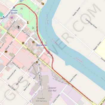
Name: Maryborough Mary Ann Steam train trail, distance, elevation, map, profile, GPS track
Start: Maryborough, Fraser Coast Regional, Queensland, Australia (-25.53900 152.70645)
End: Maryborough, Fraser Coast Regional, Queensland, Australia (-25.53903 152.70647)
Coordinates: -25.54482 152.70338 -25.53505 152.71188
Other hiking, mountain biking, running and outdoor activity trails
Click on a trail to view its statistics, map and profile.
Maryborough - Sandy Creek Bible Camp
Australia > Queensland > Maryborough
#Bike
Distance: 26.9 mi • Elevation gain: 1,194 ft • Maximum elevation: 371 ft