Maryborough - Sandy Creek Bible Camp
#Bike
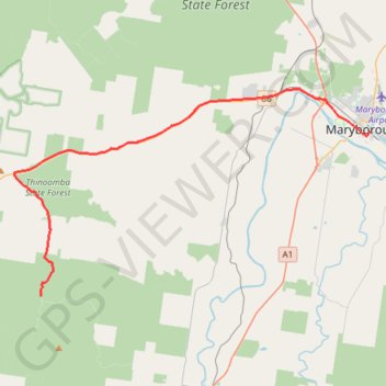
- Distance: 26.9 mi
- Elevation gain: 1,194 ft
- Maximum elevation: 371 ft
- Elevation loss: 948 ft
- Minimum elevation: 20 ft
Interactive trail map
Trail profile
- Distance: 26.9 mi
- Elevation gain: 1,194 ft
- Maximum elevation: 371 ft
- Elevation loss: 948 ft
- Minimum elevation: 20 ft
About this trail
Name: Maryborough - Sandy Creek Bible Camp trail, distance, elevation, map, profile, GPS track
Start: Wharf Street, Maryborough, Fraser Coast Regional, Queensland, Australia (-25.53973 152.70683)
Coordinates: -25.65611 152.42757 -25.50995 152.70683
Other hiking, mountain biking, running and outdoor activity trails
Click on a trail to view its statistics, map and profile.
Maryborough Mary Ann Steam train
Australia > Queensland > Maryborough
AU, Qld, Railway
Distance: 1.9 mi • Elevation gain: 52 ft • Maximum elevation: 33 ft