Rim Trail and Gorge Trail Loop in Robert H. Treman State Park
The Rim Trail and Gorge Trail Loop at Robert H. Treman State Park offers a scenic and immersive hiking experience through lush woodlands, rocky cliffs, and cascading waterfalls. As you walk the route along Enfield Creek, you'll encounter the dramatic Lucifer Falls, one of the park's most iconic sights, where visitors can admire its stunning 115-foot drop from multiple vantage points. The trail weaves past serene streams, dense greenery, and stone staircases, providing hikers with moments of quiet reflection as well as invigorating climbs, making it a well-rounded adventure for nature enthusiasts. #Hiking #Loop #Gorge #Forest #Nature #River #Waterfall
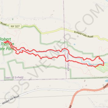
- Distance: 4.3 mi
- Elevation gain: 994 ft
- Maximum elevation: 1,014 ft
- Elevation loss: 994 ft
- Minimum elevation: 482 ft
- Moving time: 1 h 40 m
- Moving speed: 2.6 mph
- Maximum speed: 5.6 mph
- Total time: 1 h 46 m
- Global speed: 2.4 mph
Interactive trail map
Trail profile
- Distance: 4.3 mi
- Elevation gain: 994 ft
- Maximum elevation: 1,014 ft
- Elevation loss: 994 ft
- Minimum elevation: 482 ft
- Moving time: 1 h 40 m
- Moving speed: 2.6 mph
- Maximum speed: 5.6 mph
- Total time: 1 h 46 m
- Global speed: 2.4 mph
About this trail
Name: Rim Trail and Gorge Trail Loop in Robert H. Treman State Park trail, distance, elevation, map, profile, GPS track
Start: Park Lane, Town of Ithaca, Tompkins County, New York, United States (42.39805 -76.55716)
End: Park Lane, Town of Ithaca, Tompkins County, New York, United States (42.39804 -76.55720)
Coordinates: 42.39644 -76.58837 42.40265 -76.55638
Topography: Town of Ithaca topographic map, elevation, terrain