Grassy Ridge Bald via Appalachian Trail in Pisgah National Forest
The Grassy Ridge Bald hike via the Appalachian Trail in the Roan Highlands is a standout experience for nature lovers. This trek features a progression through three scenic balds—Round Bald, Jane Bald, and Grassy Ridge Bald—each offering increasingly expansive views of the Blue Ridge Mountains and beyond. Along the way, you'll encounter wild azaleas, rhododendron tunnels, and rolling meadows, culminating in panoramic vistas from Grassy Ridge summit that include distant peaks such as Grandfather Mountain and Mt. Mitchell. #Hiking #Mountain #Forest #Nature
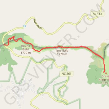
- Distance: 4.6 mi
- Elevation gain: 1,148 ft
- Maximum elevation: 6,181 ft
- Elevation loss: 1,194 ft
- Minimum elevation: 5,509 ft
- Moving time: 2 h 7 m
- Moving speed: 2.2 mph
- Maximum speed: 6.1 mph
- Total time: 2 h 52 m
- Global speed: 1.6 mph
Interactive trail map
Trail profile
- Distance: 4.6 mi
- Elevation gain: 1,148 ft
- Maximum elevation: 6,181 ft
- Elevation loss: 1,194 ft
- Minimum elevation: 5,509 ft
- Moving time: 2 h 7 m
- Moving speed: 2.2 mph
- Maximum speed: 6.1 mph
- Total time: 2 h 52 m
- Global speed: 1.6 mph
About this trail
Name: Grassy Ridge Bald via Appalachian Trail in Pisgah National Forest trail, distance, elevation, map, profile, GPS track
Coordinates: 36.09994 -82.11033 36.10849 -82.08071
Topography: Mitchell County topographic map, elevation, terrain
Other hiking, mountain biking, running and outdoor activity trails
Click on a trail to view its statistics, map and profile.
Grassy Ridge Bald from Carvers Gap via Appalachian Trail in Pisgah National Forest
United States > North Carolina > Mitchell County > Glen Ayre
The hike from Carvers Gap to Grassy Ridge Bald via the Appalachian Trail offers expansive views of the Roan Highlands, considered by many to be among the most scenic sections of the Appalachian Trail. As you traverse open grassy balds like Round Bald and Jane Bald, you'll be rewarded with panoramic vistas of…
Distance: 5.0 mi • Elevation gain: 1,286 ft • Maximum elevation: 6,191 ft
Comfort Suites Airport - Shady Valley Country Store
United States > Tennessee > Blount County > Alcoa > Farrport
146 mi, 2:28
Distance: 146.3 mi • Elevation gain: 10,801 ft • Maximum elevation: 3,428 ft