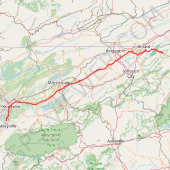
Comfort Suites Airport - Shady Valley Country Store
146 mi, 2:28
- Distance: 146.3 mi
- Elevation gain: 10,801 ft
- Maximum elevation: 3,428 ft
- Elevation loss: 8,960 ft
- Minimum elevation: 794 ft
Interactive trail map
Trail profile
- Distance: 146.3 mi
- Elevation gain: 10,801 ft
- Maximum elevation: 3,428 ft
- Elevation loss: 8,960 ft
- Minimum elevation: 794 ft
About this trail
Name: Comfort Suites Airport - Shady Valley Country Store trail, distance, elevation, map, profile, GPS track
Coordinates: 35.81193 -83.98335 36.56781 -81.92840
Topography: Blount County topographic map, elevation, terrain
Other hiking, mountain biking, running and outdoor activity trails
Click on a trail to view its statistics, map and profile.
Crabtree Falls Loop Trail in Pisgah National Forest
United States > North Carolina > Yancey County
The Crabtree Falls Loop Trail, situated along the Blue Ridge Parkway in North Carolina, offers hikers a journey through a lush hardwood forest, leading to the base of a picturesque 70-foot cascade. Along the trail, one can observe diverse flora, including wildflowers in early summer and ferns near the…
Distance: 2.8 mi • Elevation gain: 525 ft • Maximum elevation: 3,766 ft
Crabtree Falls Loop Trail in Blue Ridge Parkway
United States > North Carolina > Yancey County
The Crabtree Falls Loop Trail offers a beautiful and moderately challenging hike. As you descend through a lush oak-hickory forest, you'll pass over rocky sections, switchbacks, and a series of stone steps, all of which make the journey to the falls both scenic and rewarding. At the base, the waterfall…
Distance: 2.8 mi • Elevation gain: 528 ft • Maximum elevation: 3,766 ft
Grassy Ridge Bald from Carvers Gap via Appalachian Trail in Pisgah National Forest
United States > North Carolina > Mitchell County > Glen Ayre
The hike from Carvers Gap to Grassy Ridge Bald via the Appalachian Trail offers expansive views of the Roan Highlands, considered by many to be among the most scenic sections of the Appalachian Trail. As you traverse open grassy balds like Round Bald and Jane Bald, you'll be rewarded with panoramic vistas of…
Distance: 5.0 mi • Elevation gain: 1,286 ft • Maximum elevation: 6,191 ft
Grassy Ridge Bald via Appalachian Trail in Pisgah National Forest
United States > North Carolina > Mitchell County
The Grassy Ridge Bald hike via the Appalachian Trail in the Roan Highlands is a standout experience for nature lovers. This trek features a progression through three scenic balds—Round Bald, Jane Bald, and Grassy Ridge Bald—each offering increasingly expansive views of the Blue Ridge Mountains and beyond.…
Distance: 4.6 mi • Elevation gain: 1,148 ft • Maximum elevation: 6,181 ft
Linville Falls
United States > North Carolina > Burke County
Hike from Linville Gorge Parking to Linville Falls via Erwin's View Trail, Upper Falls Overlook, Chimney View, Gorge View, Erwin's View Outlook, Linville Falls Trail, Linville River, Plunge Basin Trail, Plunge Basin Overlook and Plunge Basin in the Blue Ridge Parkway and the Pisgah National Forest. #Hiking…
Distance: 4.9 mi • Elevation gain: 1,355 ft • Maximum elevation: 3,343 ft
Laurel Fork Falls via Appalachian Trail
United States > Tennessee > Carter County
Distance: 2.5 mi • Elevation gain: 482 ft • Maximum elevation: 2,579 ft
Carter community park
United States > Tennessee > Knox County
Distance: 1.5 mi • Elevation gain: 138 ft • Maximum elevation: 1,070 ft
Duck Island
United States > Tennessee > Sullivan County
Distance: 1.5 mi • Elevation gain: 56 ft • Maximum elevation: 1,302 ft