Import a GPX file

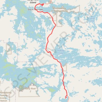
Sioux Narrows - Nestor Falls

#Bike #Sioux #Nestor

  • Distance: 36.1 mi
  • Elevation gain: 1,959 ft
  • Maximum elevation: 1,322 ft
  • Elevation loss: 1,883 ft
  • Minimum elevation: 1,053 ft

Interactive trail map

Trail profile

  • Distance: 36.1 mi
  • Elevation gain: 1,959 ft
  • Maximum elevation: 1,322 ft
  • Elevation loss: 1,883 ft
  • Minimum elevation: 1,053 ft

About this trail

Other hiking, mountain biking, running and outdoor activity trails

Click on a trail to view its statistics, map and profile.

Nestor Falls - Fort Frances

Canada > Ontario > Kenora District > Sioux Narrows-Nestor Falls Township

#Bike

Distance: 58.5 mi • Elevation gain: 1,414 ft • Maximum elevation: 1,296 ft

Kenora - Sioux Narrows

Canada > Ontario > Kenora District > Kenora

#Bike #Kenora #Sioux

Distance: 48.3 mi • Elevation gain: 2,234 ft • Maximum elevation: 1,302 ft

Gear up for your next adventure:

Solar GPS Watches - Advanced multisport watches with built-in topographic maps
🧤Tactile Hiking Gloves - Keep hands warm while operating GPS and smartphone screens
🥘Titanium Cookware - Durable, featherlight pots and pans for backpacking
📻Weather Alert Radios - Stay informed of storm risks while off-the-grid
🍳Camping Cook Set - Complete cookware for outdoor meals

As an Amazon Associate, this site earns from qualifying purchases at no extra cost to you.