Multnomah Falls
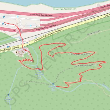
Interactive trail map
Trail profile
- Distance: 2.5 mi
- Elevation gain: 1,365 ft
- Maximum elevation: 830 ft
- Elevation loss: 1,365 ft
- Minimum elevation: 36 ft
About this trail
Name: Multnomah Falls trail, distance, elevation, map, profile, GPS track
Start: Columbia River Highway, Multnomah County, Oregon, 97010, United States (45.57882 -122.11845)
End: Columbia River Highway, Multnomah County, Oregon, 97010, United States (45.57882 -122.11845)
Coordinates: 45.57580 -122.11845 45.57882 -122.11169
Topography: Multnomah County topographic map, elevation, terrain
Other hiking, mountain biking, running and outdoor activity trails
Click on a trail to view its statistics, map and profile.
Multnomah Falls via Larch Mountain Trail in Columbia River Gorge National Scenic Area
United States > Oregon > Multnomah County
The hike from Larch Mountain Trail to Multnomah Falls offers a captivating journey through lush forests, characterized by vibrant wildflowers and stunning views of cascading waterfalls. As you ascend, you'll encounter picturesque vistas, including glimpses of the Columbia River Gorge. The trail provides a…
Distance: 2.3 mi • Elevation gain: 1,447 ft • Maximum elevation: 833 ft
Multnomah Falls, Ecola Falls and Wahkeena Falls Loop
United States > Oregon > Multnomah County
Loop hike via Larch Mountain Trail, Benson Bridge, Lower Multnomah Falls, Dutchman Falls, Wiesendanger Falls, Ecola Falls, Wahkeena Trail, Fairy Falls, Lemmons Viewpoint, Wahkeena Falls and Return Trail in the Mount Hood National Forest above the Benson Lake and the Columbia River. #Hiking #Loop #Falls #River…
Distance: 5.7 mi • Elevation gain: 3,419 ft • Maximum elevation: 1,660 ft
Wahkeena Trail and Larch Mountain Trail Loop via Wahkeena Falls and Multnomah Falls in Columbia River Gorge National Scenic Area
United States > Oregon > Multnomah County
The Wahkeena Trail and Larch Mountain Trail Loop offers a captivating hiking experience through the lush landscapes of the Columbia River Gorge. Hikers will encounter stunning vistas, including the iconic Multnomah Falls and the serene Wahkeena Falls, alongside charming features like Fairy Falls and…
Distance: 5.5 mi • Elevation gain: 2,664 ft • Maximum elevation: 1,667 ft
Northern part of the Pacific Crest Trail (PCT)
United States > Oregon > Klamath County
Hike on the Pacific Crest National Scenic Trail from Crater Lake to Canada Border through Oregon and Washington along the Sierra Nevada and Cascade mountain ranges. #Hiking #Mountain #SierraNevada #Cascade #Nature #Forest #Park #PCT
Distance: 744.6 mi • Elevation gain: 145,367 ft • Maximum elevation: 7,569 ft
Expedition to Sedum Ridge
United States > Oregon > Multnomah County > Portland
Distance: 133.4 mi • Elevation gain: 16,709 ft • Maximum elevation: 3,835 ft