Make a donation
Gear up for your next adventure:
As an Amazon Associate, this site earns from qualifying purchases at no extra cost to you.
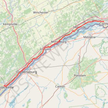
Brockville - Cornwall
#Bike
- Distance: 62.2 mi
- Elevation gain: 978 ft
- Maximum elevation: 335 ft
- Elevation loss: 1,109 ft
- Minimum elevation: 203 ft
Interactive trail map
Make a donation
Gear up for your next adventure:
As an Amazon Associate, this site earns from qualifying purchases at no extra cost to you.
Trail profile
- Distance: 62.2 mi
- Elevation gain: 978 ft
- Maximum elevation: 335 ft
- Elevation loss: 1,109 ft
- Minimum elevation: 203 ft
Make a donation
Gear up for your next adventure:
As an Amazon Associate, this site earns from qualifying purchases at no extra cost to you.
About this trail
Name: Brockville - Cornwall trail, distance, elevation, map, profile, GPS track
End: 1224, Brookdale Avenue, Cornwall, Eastern Ontario, Ontario, K6J 5B1, Canada (45.02747 -74.75204)
Coordinates: 44.59208 -75.69923 45.03500 -74.75204
Make a donation
Gear up for your next adventure:
As an Amazon Associate, this site earns from qualifying purchases at no extra cost to you.
Other hiking, mountain biking, running and outdoor activity trails
Click on a trail to view its statistics, map and profile.
Brockville - Lancaster
Canada > Ontario > Brockville > Brockville
Saint-Laurent River. #Bike #SaintLaurent
Distance: 84.1 mi • Elevation gain: 1,604 ft • Maximum elevation: 331 ft
Brockville - Ottawa
Canada > Ontario > Brockville > Brockville
#Bike #Brockville #Ottawa
Distance: 73.6 mi • Elevation gain: 1,230 ft • Maximum elevation: 440 ft
Make a donation
Gear up for your next adventure:
As an Amazon Associate, this site earns from qualifying purchases at no extra cost to you.
Cornwall Bike Path Loop
Canada > Ontario > Cornwall > Cornwall
Distance: 18.8 mi • Elevation gain: 505 ft • Maximum elevation: 226 ft
Guindon Park Hike
Canada > Ontario > Cornwall > Cornwall
Distance: 3.9 mi • Elevation gain: 69 ft • Maximum elevation: 243 ft
Cornwall Cycling
Canada > Ontario > Cornwall > Cornwall
Distance: 35.6 mi • Elevation gain: 1,093 ft • Maximum elevation: 289 ft