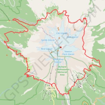
Mount Hood Loop via Timberline Trail
Interactive trail map
Trail profile
- Distance: 42.3 mi
- Elevation gain: 11,785 ft
- Maximum elevation: 7,326 ft
- Elevation loss: 11,785 ft
- Minimum elevation: 3,268 ft
About this trail
Name: Mount Hood Loop via Timberline Trail trail, distance, elevation, map, profile, GPS track
Start: Timberline Highway, Clackamas County, Oregon, 97028, United States (45.33002 -121.70886)
End: Timberline Highway, Clackamas County, Oregon, 97028, United States (45.32994 -121.70876)
Coordinates: 45.32039 -121.78415 45.41417 -121.63319
Topography: Clackamas County topographic map, elevation, terrain
Other hiking, mountain biking, running and outdoor activity trails
Click on a trail to view its statistics, map and profile.
Ramona Falls Loop via Sandy River Trail, Pacific Crest Trail and Ramona Falls Trail
United States > Oregon > Clackamas County
The Ramona Falls Loop in Oregon's Mount Hood Wilderness offers hikers a journey through lush forests, a crossing over the Sandy River, and the serene beauty of Ramona Falls cascading over basalt columns. Along the trail, one can enjoy views of Mount Hood and vibrant rhododendron blooms in season. The path is…
Distance: 7.5 mi • Elevation gain: 1,309 ft • Maximum elevation: 3,599 ft
Northern part of the Pacific Crest Trail (PCT)
United States > Oregon > Klamath County
Hike on the Pacific Crest National Scenic Trail from Crater Lake to Canada Border through Oregon and Washington along the Sierra Nevada and Cascade mountain ranges. #Hiking #Mountain #SierraNevada #Cascade #Nature #Forest #Park #PCT
Distance: 744.6 mi • Elevation gain: 145,367 ft • Maximum elevation: 7,569 ft
Pacific Crest National Scenic Trail (PCT) #2000
United States > Oregon > Clackamas County
Distance: 9.3 mi • Elevation gain: 1,188 ft • Maximum elevation: 6,089 ft
Timberline Trail #600 East and South
United States > Oregon > Hood River County
Distance: 10.1 mi • Elevation gain: 2,451 ft • Maximum elevation: 6,470 ft
Timberline Trail #600 North and East
United States > Oregon > Hood River County
Distance: 12.2 mi • Elevation gain: 3,773 ft • Maximum elevation: 7,326 ft