Make a donation
Gear up for your next adventure:
As an Amazon Associate, this site earns from qualifying purchases at no extra cost to you.
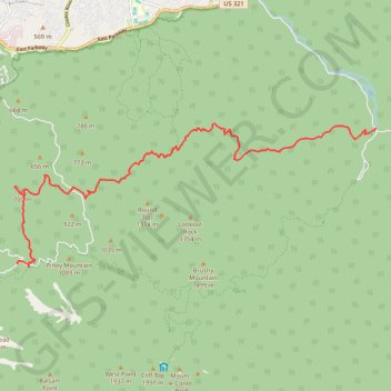
Grapeyard Ridge Trail to Baskins Creek Falls
Hike from Greenbrier Road to Cherokee Orchard Road via Grapeyard Ridge Trail, Baskins Creek Trail and Baskins Creek Falls in the Great Smoky Mountains National Park. #Hiking #Nature #Mountain #Forest #Park #Falls #River
- Distance: 10.9 mi
- Elevation gain: 3,333 ft
- Maximum elevation: 3,022 ft
- Elevation loss: 2,385 ft
- Minimum elevation: 1,693 ft
- Moving time: 5 h 35 m
- Moving speed: 2.0 mph
- Maximum speed: 3.1 mph
- Total time: 5 h 57 m
- Global speed: 1.8 mph
Interactive trail map
Make a donation
Gear up for your next adventure:
As an Amazon Associate, this site earns from qualifying purchases at no extra cost to you.
Trail profile
- Distance: 10.9 mi
- Elevation gain: 3,333 ft
- Maximum elevation: 3,022 ft
- Elevation loss: 2,385 ft
- Minimum elevation: 1,693 ft
- Moving time: 5 h 35 m
- Moving speed: 2.0 mph
- Maximum speed: 3.1 mph
- Total time: 5 h 57 m
- Global speed: 1.8 mph
Make a donation
Gear up for your next adventure:
As an Amazon Associate, this site earns from qualifying purchases at no extra cost to you.
About this trail
Name: Grapeyard Ridge Trail to Baskins Creek Falls trail, distance, elevation, map, profile, GPS track
Coordinates: 35.67709 -83.48242 35.70923 -83.38259
Topography: Sevier County topographic map, elevation, terrain
Make a donation
Gear up for your next adventure:
As an Amazon Associate, this site earns from qualifying purchases at no extra cost to you.
Other hiking, mountain biking, running and outdoor activity trails
Click on a trail to view its statistics, map and profile.
Grotto Falls via Trillium Gap Trail in Great Smoky Mountains National Park
United States > Tennessee > Sevier County
The hike to Grotto Falls offers a refreshing woodland experience within Great Smoky Mountains National Park. The trail takes you through a lush forest, featuring streams and wildflowers, leading to the 25-foot high Grotto Falls, where you can walk behind the waterfall—a rare and exciting feature of the hike.…
Distance: 2.7 mi • Elevation gain: 925 ft • Maximum elevation: 3,819 ft
Grotto Falls via Trillium Gap Trail in Great Smoky Mountains National Park
United States > Tennessee > Sevier County
Hiking the Trillium Gap Trail to Grotto Falls offers an immersive journey through old-growth hemlock forests, where vibrant wildflowers adorn the path. The trail's highlight is Grotto Falls, a 25-foot waterfall behind which hikers can walk, providing a unique perspective of the cascading water. #Hiking…
Distance: 2.6 mi • Elevation gain: 915 ft • Maximum elevation: 3,816 ft
Great Smoky Mountains Appalachian Trail
United States > North Carolina > Clay County
Hike through Great Smoky Mountains along Appalachian Trail via Standing Indian, Ridgepole Mountain, Yellow Bald, Wine Spring Bald, Copper Ridge Bald, Cheoah Bald, Wauchecha Bald, Fontana Dam, Thunderhead Mountain, Clingmans Dome, Mount Kephart and Mount Guyot. #Hiking #Mountain #Nature #Forest #Lake…
Distance: 144.0 mi • Elevation gain: 29,111 ft • Maximum elevation: 6,604 ft
Make a donation
Gear up for your next adventure:
As an Amazon Associate, this site earns from qualifying purchases at no extra cost to you.