Make a donation
Gear up for your next adventure:
As an Amazon Associate, this site earns from qualifying purchases at no extra cost to you.
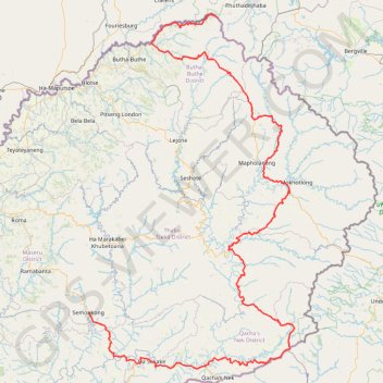
Lesotho - Semonkong
Interactive trail map
Make a donation
Gear up for your next adventure:
As an Amazon Associate, this site earns from qualifying purchases at no extra cost to you.
Trail profile
- Distance: 355.7 mi
- Elevation gain: 52,900 ft
- Maximum elevation: 10,751 ft
- Elevation loss: 52,323 ft
- Minimum elevation: 4,961 ft
Make a donation
Gear up for your next adventure:
As an Amazon Associate, this site earns from qualifying purchases at no extra cost to you.
About this trail
Name: Lesotho - Semonkong trail, distance, elevation, map, profile, GPS track
End: A5, Ha Lepae (Semonkong), Semonkong, Maseru District, Lesotho (-29.84053 28.05309)
Coordinates: -30.07824 28.05308 -28.57545 29.05633
Make a donation
Gear up for your next adventure:
As an Amazon Associate, this site earns from qualifying purchases at no extra cost to you.
Other hiking, mountain biking, running and outdoor activity trails
Click on a trail to view its statistics, map and profile.
Thukela Falls - Sentinel
South Africa > Free State > Thabo Mofutsanyana District Municipality > Maluti-a-Phofung Local Municipality
Distance: 7.9 mi • Elevation gain: 3,291 ft • Maximum elevation: 9,862 ft