Thank you for supporting this site ❤️
Make a donation
Make a donation
Gear up for your next adventure:
As an Amazon Associate, this site earns from qualifying purchases at no extra cost to you.
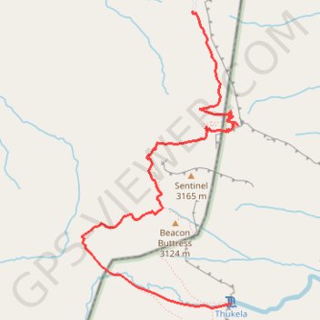
Thukela Falls - Sentinel
- Distance: 7.9 mi
- Elevation gain: 3,291 ft
- Maximum elevation: 9,862 ft
- Elevation loss: 3,287 ft
- Minimum elevation: 8,343 ft
Interactive trail map
Thank you for supporting this site ❤️
Make a donation
Make a donation
Gear up for your next adventure:
As an Amazon Associate, this site earns from qualifying purchases at no extra cost to you.
Trail profile
- Distance: 7.9 mi
- Elevation gain: 3,291 ft
- Maximum elevation: 9,862 ft
- Elevation loss: 3,287 ft
- Minimum elevation: 8,343 ft
Thank you for supporting this site ❤️
Make a donation
Make a donation
Gear up for your next adventure:
As an Amazon Associate, this site earns from qualifying purchases at no extra cost to you.
About this trail
Name: Thukela Falls - Sentinel trail, distance, elevation, map, profile, GPS track
Coordinates: -28.75281 28.88000 -28.72741 28.89529
Thank you for supporting this site ❤️
Make a donation
Make a donation
Gear up for your next adventure:
As an Amazon Associate, this site earns from qualifying purchases at no extra cost to you.
Other hiking, mountain biking, running and outdoor activity trails
Click on a trail to view its statistics, map and profile.