
Catfish Loop Trail in Clarence Fahnestock Memorial State Park
Starting from Dennytown Road in Clarence Fahnestock Memorial State Park, the Catfish Loop Trail briefly follows the Appalachian Trail before entering quiet Hudson Highlands woodland shaped by mountain laurel, old stone walls, small streams and wetland pockets.
The route then moves through rock-strewn ridge terrain, passing lichen-covered boulders, a narrow rock passage and a west-facing overlook toward Crows Nest and Storm King before descending through quieter forest toward the Catfish Pond.
The return continues through laurel thickets, shallow valleys, seasonal wet areas, farm-wall remnants, scattered rock outcrops and occasional glimpses toward Duck Pond before rejoining the Appalachian Trail back to Dennytown Road.
#Hiking #Loop #Forest #Nature #Park #Pond #Rocks #Overlook #Streams
- Distance: 4.5 mi
- Elevation gain: 446 ft
- Maximum elevation: 1,004 ft
- Elevation loss: 449 ft
- Minimum elevation: 784 ft
- Moving time: 2 h 25 m
- Moving speed: 1.9 mph
- Maximum speed: 3.5 mph
- Total time: 3 h 14 m
- Global speed: 1.4 mph
Interactive trail map
Trail profile
- Distance: 4.5 mi
- Elevation gain: 446 ft
- Maximum elevation: 1,004 ft
- Elevation loss: 449 ft
- Minimum elevation: 784 ft
- Moving time: 2 h 25 m
- Moving speed: 1.9 mph
- Maximum speed: 3.5 mph
- Total time: 3 h 14 m
- Global speed: 1.4 mph
About this trail
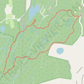
Name: Catfish Loop Trail in Clarence Fahnestock Memorial State Park trail, distance, elevation, map, profile, GPS track
Coordinates: 41.40623 -73.89409 41.42210 -73.86869
Topography: Putnam County topographic map, elevation, terrain
Other hiking, mountain biking, running and outdoor activity trails
Click on a trail to view its statistics, map and profile.
Fabulous Fahnestock Trail 25k
United States > New York > Putnam County > Town of Putnam Valley > Dennytown
Distance: 16.1 mi • Elevation gain: 2,113 ft • Maximum elevation: 1,040 ft