Thank you for supporting this site ❤️
Make a donation
Make a donation
Gear up for your next adventure:
As an Amazon Associate, this site earns from qualifying purchases at no extra cost to you.
Munro hillwalk Cairngorm and northern corries
- Distance: 9.1 mi
- Elevation gain: 2,992 ft
- Maximum elevation: 4,081 ft
- Elevation loss: 2,989 ft
- Minimum elevation: 2,047 ft
- Moving time: 4 h 36 m
- Moving speed: 2.0 mph
- Maximum speed: 3.6 mph
- Total time: 5 h 7 m
- Global speed: 1.8 mph
Interactive trail map
Thank you for supporting this site ❤️
Make a donation
Make a donation
Gear up for your next adventure:
As an Amazon Associate, this site earns from qualifying purchases at no extra cost to you.
Trail profile
- Distance: 9.1 mi
- Elevation gain: 2,992 ft
- Maximum elevation: 4,081 ft
- Elevation loss: 2,989 ft
- Minimum elevation: 2,047 ft
- Moving time: 4 h 36 m
- Moving speed: 2.0 mph
- Maximum speed: 3.6 mph
- Total time: 5 h 7 m
- Global speed: 1.8 mph
Thank you for supporting this site ❤️
Make a donation
Make a donation
Gear up for your next adventure:
As an Amazon Associate, this site earns from qualifying purchases at no extra cost to you.
About this trail
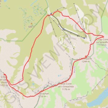
Name: Munro hillwalk Cairngorm and northern corries trail, distance, elevation, map, profile, GPS track
Coordinates: 57.10026 -3.70491 57.13494 -3.63099
Thank you for supporting this site ❤️
Make a donation
Make a donation
Gear up for your next adventure:
As an Amazon Associate, this site earns from qualifying purchases at no extra cost to you.
Other hiking, mountain biking, running and outdoor activity trails
Click on a trail to view its statistics, map and profile.
Cairngorms hike
United Kingdom > Scotland > Highland > Aviemore
Distance: 50.2 mi • Elevation gain: 9,846 ft • Maximum elevation: 4,304 ft