Make a donation
Gear up for your next adventure:
As an Amazon Associate, this site earns from qualifying purchases at no extra cost to you.
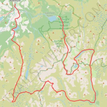
Cairngorms hike
- Distance: 50.2 mi
- Elevation gain: 9,846 ft
- Maximum elevation: 4,304 ft
- Elevation loss: 9,449 ft
- Minimum elevation: 679 ft
- Moving time: 19 h 3 m
- Moving speed: 2.6 mph
- Maximum speed: 5.5 mph
- Total time: 3 d 45 m
- Global speed: 0.7 mph
Interactive trail map
Make a donation
Gear up for your next adventure:
As an Amazon Associate, this site earns from qualifying purchases at no extra cost to you.
Trail profile
- Distance: 50.2 mi
- Elevation gain: 9,846 ft
- Maximum elevation: 4,304 ft
- Elevation loss: 9,449 ft
- Minimum elevation: 679 ft
- Moving time: 19 h 3 m
- Moving speed: 2.6 mph
- Maximum speed: 5.5 mph
- Total time: 3 d 45 m
- Global speed: 0.7 mph
Make a donation
Gear up for your next adventure:
As an Amazon Associate, this site earns from qualifying purchases at no extra cost to you.
About this trail
Name: Cairngorms hike trail, distance, elevation, map, profile, GPS track
Start: Aviemore, B9152, Aviemore, Highland, Scotland, PH22 1PD, United Kingdom (57.18787 -3.82863)
End: Cairngorm Road, Glenmore, Highland, Scotland, PH22 1QY, United Kingdom (57.16747 -3.69453)
Coordinates: 57.02092 -3.84058 57.18787 -3.57819
Make a donation
Gear up for your next adventure:
As an Amazon Associate, this site earns from qualifying purchases at no extra cost to you.
Other hiking, mountain biking, running and outdoor activity trails
Click on a trail to view its statistics, map and profile.
Munro hillwalk Sgor Gaoith Mullach Clach a' Bhlair
United Kingdom > Scotland > Highland
Distance: 18.7 mi • Elevation gain: 3,796 ft • Maximum elevation: 3,635 ft
Aviemore to Loch Garten: A Tale of Trails and Trials
United Kingdom > Scotland > Highland > Aviemore
Distance: 22.0 mi • Elevation gain: 856 ft • Maximum elevation: 801 ft
Munro hillwalk Cairngorm and northern corries
United Kingdom > Scotland > Highland
Distance: 9.1 mi • Elevation gain: 2,992 ft • Maximum elevation: 4,081 ft
Glenmore - Meall a' Bhuachaille - Ryvoan Bothy
United Kingdom > Scotland > Highland > Glenmore
Distance: 5.5 mi • Elevation gain: 1,850 ft • Maximum elevation: 2,648 ft
Make a donation
Gear up for your next adventure:
As an Amazon Associate, this site earns from qualifying purchases at no extra cost to you.
Munro hillwalk Mheadhoin Etchachan
United Kingdom > Scotland > Aberdeenshire
Munro, hillwalk, Mheadhoin, Etchachan
Distance: 18.3 mi • Elevation gain: 5,102 ft • Maximum elevation: 4,049 ft
Munro hillwalk Chaorainn Bhreac
United Kingdom > Scotland > Aberdeenshire
Munro, hillwalk, Chaorainn, Bhreac
Distance: 13.0 mi • Elevation gain: 2,051 ft • Maximum elevation: 3,550 ft
Hike up Craigellachie from Aviemore
United Kingdom > Scotland > Highland > Aviemore
Distance: 3.8 mi • Elevation gain: 942 ft • Maximum elevation: 1,614 ft