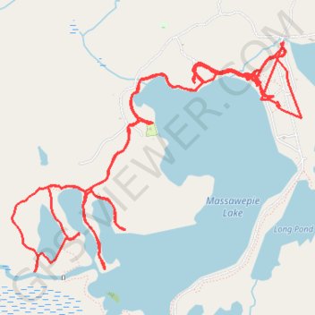
Massawepie Lake
- Distance: 13.5 mi
- Elevation gain: 902 ft
- Maximum elevation: 1,581 ft
- Elevation loss: 906 ft
- Minimum elevation: 1,509 ft
- Moving time: 5 h 25 m
- Moving speed: 2.5 mph
- Maximum speed: 15.7 mph
- Total time: 1 d 12 h
- Global speed: 0.4 mph
Interactive trail map
Trail profile
- Distance: 13.5 mi
- Elevation gain: 902 ft
- Maximum elevation: 1,581 ft
- Elevation loss: 906 ft
- Minimum elevation: 1,509 ft
- Moving time: 5 h 25 m
- Moving speed: 2.5 mph
- Maximum speed: 15.7 mph
- Total time: 1 d 12 h
- Global speed: 0.4 mph
About this trail
Name: Massawepie Lake trail, distance, elevation, map, profile, GPS track
Coordinates: 44.25033 -74.66810 44.26726 -74.63811
Topography: Saint Lawrence County topographic map, elevation, terrain
Other hiking, mountain biking, running and outdoor activity trails
Click on a trail to view its statistics, map and profile.