Make a donation
Gear up for your next adventure:
As an Amazon Associate, this site earns from qualifying purchases at no extra cost to you.
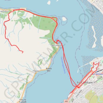
Visit of Fort William
Walk in the city center, ferry to Camusnagaul and hike to Treslaig Tower Viewpoint. #Hiking #Walking #City #Boat #Sea #Nature #Mountain #Forest #Highlands
- Distance: 9.6 mi
- Elevation gain: 1,132 ft
- Maximum elevation: 932 ft
- Elevation loss: 1,129 ft
- Minimum elevation: 0 ft
- Moving time: 4 h 3 m
- Moving speed: 2.4 mph
- Maximum speed: 8.8 mph
- Total time: 6 h 15 m
- Global speed: 1.5 mph
Interactive trail map
Make a donation
Gear up for your next adventure:
As an Amazon Associate, this site earns from qualifying purchases at no extra cost to you.
Trail profile
- Distance: 9.6 mi
- Elevation gain: 1,132 ft
- Maximum elevation: 932 ft
- Elevation loss: 1,129 ft
- Minimum elevation: 0 ft
- Moving time: 4 h 3 m
- Moving speed: 2.4 mph
- Maximum speed: 8.8 mph
- Total time: 6 h 15 m
- Global speed: 1.5 mph
Make a donation
Gear up for your next adventure:
As an Amazon Associate, this site earns from qualifying purchases at no extra cost to you.
About this trail
Name: Visit of Fort William trail, distance, elevation, map, profile, GPS track
Start: A82, An Aird, Fort William, Highland, Scotland, PH33 6DN, United Kingdom (56.81586 -5.11620)
Coordinates: 56.81498 -5.14823 56.83624 -5.10441
Make a donation
Gear up for your next adventure:
As an Amazon Associate, this site earns from qualifying purchases at no extra cost to you.
Other hiking, mountain biking, running and outdoor activity trails
Click on a trail to view its statistics, map and profile.
Great Glen Way (Fort William to Fort Augustus)
United Kingdom > Scotland > Highland > Fort William
Distance: 32.7 mi • Elevation gain: 1,962 ft • Maximum elevation: 354 ft