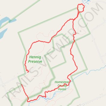
Henning Preserve Loop Trail
- Distance: 5.4 mi
- Elevation gain: 361 ft
- Maximum elevation: 1,631 ft
- Elevation loss: 430 ft
- Minimum elevation: 1,325 ft
- Moving time: 2 h 20 m
- Moving speed: 2.3 mph
- Maximum speed: 8.3 mph
- Total time: 2 h 37 m
- Global speed: 2.1 mph
Interactive trail map
Trail profile
- Distance: 5.4 mi
- Elevation gain: 361 ft
- Maximum elevation: 1,631 ft
- Elevation loss: 430 ft
- Minimum elevation: 1,325 ft
- Moving time: 2 h 20 m
- Moving speed: 2.3 mph
- Maximum speed: 8.3 mph
- Total time: 2 h 37 m
- Global speed: 2.1 mph
About this trail
Name: Henning Preserve Loop Trail trail, distance, elevation, map, profile, GPS track
Coordinates: 43.10443 -74.04019 43.12904 -74.01856
Topography: Saratoga County topographic map, elevation, terrain
Other hiking, mountain biking, running and outdoor activity trails
Click on a trail to view its statistics, map and profile.
Homestead County Forest Trails
United States > New York > Saratoga County
Distance: 6.3 mi • Elevation gain: 551 ft • Maximum elevation: 1,503 ft