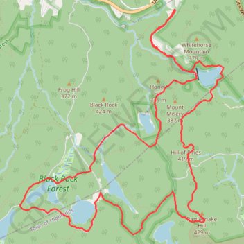
Black Rock Forest: Upper Reservoir, Aleck Meadow Reservoir, Sphagnum Pond, Tamarack Pond, Arthus Pond, Bog Meadow Pond, Rattlesnake Hill and Hill of Pines loop
Morning Loop Run
- Distance: 8.5 mi
- Elevation gain: 1,220 ft
- Maximum elevation: 1,362 ft
- Elevation loss: 1,201 ft
- Minimum elevation: 768 ft
- Moving time: 1 h 27 m
- Moving speed: 5.8 mph
- Maximum speed: 10.1 mph
- Total time: 1 h 28 m
- Global speed: 5.8 mph
Interactive trail map
Trail profile
- Distance: 8.5 mi
- Elevation gain: 1,220 ft
- Maximum elevation: 1,362 ft
- Elevation loss: 1,201 ft
- Minimum elevation: 768 ft
- Moving time: 1 h 27 m
- Moving speed: 5.8 mph
- Maximum speed: 10.1 mph
- Total time: 1 h 28 m
- Global speed: 5.8 mph
About this trail
Name: Black Rock Forest: Upper Reservoir, Aleck Meadow Reservoir, Sphagnum Pond, Tamarack Pond, Arthus Pond, Bog Meadow Pond, Rattlesnake Hill and Hill of Pines loop trail, distance, elevation, map, profile, GPS track
Coordinates: 41.39233 -74.03450 41.41862 -74.00291
Topography: Orange County topographic map, elevation, terrain
Other hiking, mountain biking, running and outdoor activity trails
Click on a trail to view its statistics, map and profile.