Make a donation
Gear up for your next adventure:
As an Amazon Associate, this site earns from qualifying purchases at no extra cost to you.
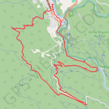
Derby Tracks - Long Shadows - Return to Sender
Interactive trail map
Make a donation
Gear up for your next adventure:
As an Amazon Associate, this site earns from qualifying purchases at no extra cost to you.
Trail profile
- Distance: 7.2 mi
- Elevation gain: 1,234 ft
- Maximum elevation: 1,362 ft
- Elevation loss: 1,234 ft
- Minimum elevation: 479 ft
Make a donation
Gear up for your next adventure:
As an Amazon Associate, this site earns from qualifying purchases at no extra cost to you.
About this trail
Name: Derby Tracks - Long Shadows - Return to Sender trail, distance, elevation, map, profile, GPS track
Start: Esplanade, Derby, Dorset, Tasmania, 7264, Australia (-41.14625 147.80214)
End: Esplanade, Derby, Dorset, Tasmania, 7264, Australia (-41.14625 147.80214)
Coordinates: -41.16953 147.78929 -41.14612 147.81563
Make a donation
Gear up for your next adventure:
As an Amazon Associate, this site earns from qualifying purchases at no extra cost to you.
Other hiking, mountain biking, running and outdoor activity trails
Click on a trail to view its statistics, map and profile.
MTB - Derby - Longshadows upper and 333 down
Distance: 7.9 mi • Elevation gain: 1,280 ft • Maximum elevation: 1,381 ft
MTB - Derby
Distance: 8.4 mi • Elevation gain: 1,594 ft • Maximum elevation: 1,352 ft