Make a donation
Gear up for your next adventure:
As an Amazon Associate, this site earns from qualifying purchases at no extra cost to you.
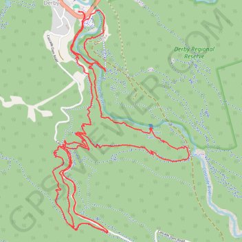
MTB - Derby
- Distance: 8.4 mi
- Elevation gain: 1,594 ft
- Maximum elevation: 1,352 ft
- Elevation loss: 1,594 ft
- Minimum elevation: 486 ft
- Moving time: 1 h 15 m
- Moving speed: 6.7 mph
- Maximum speed: 22.5 mph
- Total time: 1 h 42 m
- Global speed: 4.9 mph
Interactive trail map
Make a donation
Gear up for your next adventure:
As an Amazon Associate, this site earns from qualifying purchases at no extra cost to you.
Trail profile
- Distance: 8.4 mi
- Elevation gain: 1,594 ft
- Maximum elevation: 1,352 ft
- Elevation loss: 1,594 ft
- Minimum elevation: 486 ft
- Moving time: 1 h 15 m
- Moving speed: 6.7 mph
- Maximum speed: 22.5 mph
- Total time: 1 h 42 m
- Global speed: 4.9 mph
Make a donation
Gear up for your next adventure:
As an Amazon Associate, this site earns from qualifying purchases at no extra cost to you.
About this trail
Name: MTB - Derby trail, distance, elevation, map, profile, GPS track
Start: Main Street, Derby, Dorset, Tasmania, 7264, Australia (-41.14975 147.80390)
End: Main Street, Derby, Dorset, Tasmania, 7264, Australia (-41.14980 147.80390)
Coordinates: -41.16771 147.80111 -41.14957 147.81581
Make a donation
Gear up for your next adventure:
As an Amazon Associate, this site earns from qualifying purchases at no extra cost to you.
Other hiking, mountain biking, running and outdoor activity trails
Click on a trail to view its statistics, map and profile.
MTB - Derby - Longshadows upper and 333 down
Distance: 7.9 mi • Elevation gain: 1,280 ft • Maximum elevation: 1,381 ft