Make a donation
Gear up for your next adventure:
As an Amazon Associate, this site earns from qualifying purchases at no extra cost to you.
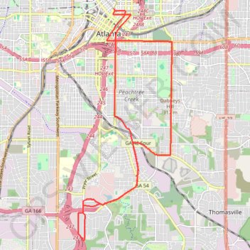
Atlanta Critical Mass
- Distance: 14.5 mi
- Elevation gain: 1,096 ft
- Maximum elevation: 1,122 ft
- Elevation loss: 1,106 ft
- Minimum elevation: 863 ft
- Moving time: 1 h 47 m
- Moving speed: 8.1 mph
- Maximum speed: 23.0 mph
- Total time: 2 h 4 m
- Global speed: 7.0 mph
Interactive trail map
Make a donation
Gear up for your next adventure:
As an Amazon Associate, this site earns from qualifying purchases at no extra cost to you.
Trail profile
- Distance: 14.5 mi
- Elevation gain: 1,096 ft
- Maximum elevation: 1,122 ft
- Elevation loss: 1,106 ft
- Minimum elevation: 863 ft
- Moving time: 1 h 47 m
- Moving speed: 8.1 mph
- Maximum speed: 23.0 mph
- Total time: 2 h 4 m
- Global speed: 7.0 mph
Make a donation
Gear up for your next adventure:
As an Amazon Associate, this site earns from qualifying purchases at no extra cost to you.
About this trail
Name: Atlanta Critical Mass trail, distance, elevation, map, profile, GPS track
Coordinates: 33.68905 -84.40075 33.75602 -84.36812
Topography: Atlanta topographic map, elevation, terrain
Make a donation
Gear up for your next adventure:
As an Amazon Associate, this site earns from qualifying purchases at no extra cost to you.
Other hiking, mountain biking, running and outdoor activity trails
Click on a trail to view its statistics, map and profile.
Atlanta, Lilburn, Yellow River Park, Panola, Jonesboro
United States > Georgia > Fayette County > Peachtree City > Stop
Distance: 208.1 mi • Elevation gain: 13,314 ft • Maximum elevation: 1,109 ft
Atlanta Critical Mass (partial)
United States > Georgia > Fulton County > Atlanta
Distance: 12.3 mi • Elevation gain: 863 ft • Maximum elevation: 1,181 ft
Atlanta Critical Mass bike ride
United States > Georgia > Fulton County > Atlanta
Distance: 8.8 mi • Elevation gain: 679 ft • Maximum elevation: 1,184 ft
The Atlanta Donut Ride
United States > Georgia > Fulton County > Atlanta
Distance: 10.2 mi • Elevation gain: 778 ft • Maximum elevation: 1,155 ft
Make a donation
Gear up for your next adventure:
As an Amazon Associate, this site earns from qualifying purchases at no extra cost to you.