Make a donation
Gear up for your next adventure:
As an Amazon Associate, this site earns from qualifying purchases at no extra cost to you.
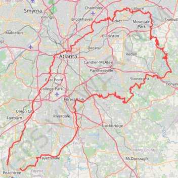
Atlanta, Lilburn, Yellow River Park, Panola, Jonesboro
- Distance: 208.1 mi
- Elevation gain: 13,314 ft
- Maximum elevation: 1,109 ft
- Elevation loss: 13,287 ft
- Minimum elevation: 689 ft
- Moving time: 16 h 21 m
- Moving speed: 12.7 mph
- Maximum speed: 36.6 mph
- Total time: 17 h 36 m
- Global speed: 11.8 mph
Interactive trail map
Make a donation
Gear up for your next adventure:
As an Amazon Associate, this site earns from qualifying purchases at no extra cost to you.
Trail profile
- Distance: 208.1 mi
- Elevation gain: 13,314 ft
- Maximum elevation: 1,109 ft
- Elevation loss: 13,287 ft
- Minimum elevation: 689 ft
- Moving time: 16 h 21 m
- Moving speed: 12.7 mph
- Maximum speed: 36.6 mph
- Total time: 17 h 36 m
- Global speed: 11.8 mph
Make a donation
Gear up for your next adventure:
As an Amazon Associate, this site earns from qualifying purchases at no extra cost to you.
About this trail
Name: Atlanta, Lilburn, Yellow River Park, Panola, Jonesboro trail, distance, elevation, map, profile, GPS track
Coordinates: 33.41060 -84.60712 33.89226 -84.02246
Topography: Fayette County topographic map, elevation, terrain
Make a donation
Gear up for your next adventure:
As an Amazon Associate, this site earns from qualifying purchases at no extra cost to you.
Other hiking, mountain biking, running and outdoor activity trails
Click on a trail to view its statistics, map and profile.
Bamboo Forest via East Palisades Loop in Chattahoochee River National Recreation Area
United States > Georgia > Fulton County > Atlanta
The Bamboo Forest via East Palisades Loop offers a unique hiking experience that brings you close to nature while being conveniently located near Atlanta. Hikers can enjoy views of the Chattahoochee River, traverse through a small but enchanting bamboo forest, and explore sections with striking rock…
Distance: 4.1 mi • Elevation gain: 617 ft • Maximum elevation: 1,017 ft
East Palisades and Bamboo Forest Loop Trail
United States > Georgia > Fulton County > Atlanta
The East Palisades and Bamboo Forest Loop Trail in the Chattahoochee River National Recreation Area offers hikers a scenic journey through diverse landscapes. As you traverse the trail, you'll encounter the towering bamboo forest—a unique and unexpected feature in Georgia—that creates a serene atmosphere…
Distance: 4.4 mi • Elevation gain: 673 ft • Maximum elevation: 1,017 ft
Ride from Smyrna to Marietta on the Mountain to River Trail
United States > Georgia > Cobb County > Smyrna
Distance: 13.6 mi • Elevation gain: 423 ft • Maximum elevation: 1,155 ft
Make a donation
Gear up for your next adventure:
As an Amazon Associate, this site earns from qualifying purchases at no extra cost to you.
More bike ride on the Silver Comet Trail (and some other side quests)
United States > Georgia > Polk County
Distance: 47.8 mi • Elevation gain: 2,802 ft • Maximum elevation: 1,148 ft
Bike ride to bus stop to go into town, then circle back along the silver comet trail and ride the newly paved part of the beltline connector
United States > Georgia > Cobb County > Smyrna
Distance: 14.9 mi • Elevation gain: 896 ft • Maximum elevation: 1,093 ft
Bike ride down the Silver Comet Trail (and some side quests)
United States > Georgia > Cobb County > Smyrna
Distance: 82.1 mi • Elevation gain: 4,278 ft • Maximum elevation: 1,152 ft
Make a donation
Gear up for your next adventure:
As an Amazon Associate, this site earns from qualifying purchases at no extra cost to you.
Powder Springs, Allatoona trails, Dallas, Chatt Hills
United States > Georgia > Fayette County > Tyrone > Stop
Distance: 198.6 mi • Elevation gain: 12,484 ft • Maximum elevation: 1,243 ft
A Better Cobb Group Ride - Mountain to River Trail
United States > Georgia > Cobb County > Smyrna
Distance: 18.4 mi • Elevation gain: 722 ft • Maximum elevation: 1,158 ft
Morrow, Forest Park, Atlanta, Fairburn
United States > Georgia > Fayette County > Peachtree City
Distance: 115.6 mi • Elevation gain: 5,984 ft • Maximum elevation: 1,066 ft
Bicycle ride around Smyrna, mostly on bike trails
United States > Georgia > Cobb County > Smyrna
Distance: 10.3 mi • Elevation gain: 764 ft • Maximum elevation: 1,093 ft
Make a donation
Gear up for your next adventure:
As an Amazon Associate, this site earns from qualifying purchases at no extra cost to you.
Atlanta Critical Mass (partial)
United States > Georgia > Fulton County > Atlanta
Distance: 12.3 mi • Elevation gain: 863 ft • Maximum elevation: 1,181 ft
Atlanta Critical Mass bike ride
United States > Georgia > Fulton County > Atlanta
Distance: 8.8 mi • Elevation gain: 679 ft • Maximum elevation: 1,184 ft
The Atlanta Donut Ride
United States > Georgia > Fulton County > Atlanta
Distance: 10.2 mi • Elevation gain: 778 ft • Maximum elevation: 1,155 ft
Atlanta Critical Mass
United States > Georgia > Fulton County > Atlanta
Distance: 14.5 mi • Elevation gain: 1,096 ft • Maximum elevation: 1,122 ft
Make a donation
Gear up for your next adventure:
As an Amazon Associate, this site earns from qualifying purchases at no extra cost to you.
Walk around Lenox Park
United States > Georgia > DeKalb County > Brookhaven
Distance: 1.4 mi • Elevation gain: 131 ft • Maximum elevation: 955 ft