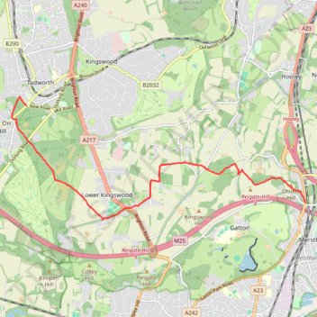
Walk Tadworth to Merstham
Tadworth, Banstead Heath, Lowert Kingswood, Merstham
- Distance: 6.3 mi
- Elevation gain: 325 ft
- Maximum elevation: 636 ft
- Elevation loss: 568 ft
- Minimum elevation: 351 ft
- Moving time: 2 h 44 m
- Moving speed: 2.3 mph
- Maximum speed: 4.2 mph
- Total time: 2 h 57 m
- Global speed: 2.1 mph
Interactive trail map
Trail profile
- Distance: 6.3 mi
- Elevation gain: 325 ft
- Maximum elevation: 636 ft
- Elevation loss: 568 ft
- Minimum elevation: 351 ft
- Moving time: 2 h 44 m
- Moving speed: 2.3 mph
- Maximum speed: 4.2 mph
- Total time: 2 h 57 m
- Global speed: 2.1 mph
About this trail
Name: Walk Tadworth to Merstham trail, distance, elevation, map, profile, GPS track
Coordinates: 51.26453 -0.24141 51.28835 -0.15070
Other hiking, mountain biking, running and outdoor activity trails
Click on a trail to view its statistics, map and profile.
Walk Redhill to Hooley via The Moors Nature Reserve, South Mertstham, Tollsworth Manor, Alderstead Heath, Netherne-on-the-Hill
United Kingdom > England > Surrey > Reigate and Banstead > Redhill
Redhill, Hooley, South Mertstham, Alderstead Heath, Netherne-on-the-Hill
Distance: 6.7 mi • Elevation gain: 489 ft • Maximum elevation: 646 ft
Walk Earlswood, Merstham, Chaldon church, Fartyhing Downs, Coulson
United Kingdom > England > Surrey > Reigate and Banstead > Redhill
Distance: 10.2 mi • Elevation gain: 817 ft • Maximum elevation: 646 ft
Walk Earlswood to North Merstham, via Nutfirld Marsh, Brewer Street, Tylers Green Godstone, Gravelly Hill, North Downs Way
United Kingdom > England > Surrey > Reigate and Banstead > Redhill
Distance: 10.5 mi • Elevation gain: 771 ft • Maximum elevation: 761 ft
Walk Colley Hill, Banstead Heath, Merstham
United Kingdom > England > Surrey > Reigate and Banstead > Reigate
Olley Hill, Banstead Heath, Merstham, Surrey
Distance: 10.5 mi • Elevation gain: 784 ft • Maximum elevation: 774 ft
Walk Colley Hill, Banstead Heath
United Kingdom > England > Surrey > Reigate and Banstead > Reigate
Colley Hill, Banstead Heath, Surrey
Distance: 5.7 mi • Elevation gain: 705 ft • Maximum elevation: 774 ft
Walk Earlswood to Hooley
United Kingdom > England > Surrey > Reigate and Banstead > Redhill
South Merstham, Earlswood, Alderstead Heath, Netherne, Hooley
Distance: 7.7 mi • Elevation gain: 682 ft • Maximum elevation: 646 ft