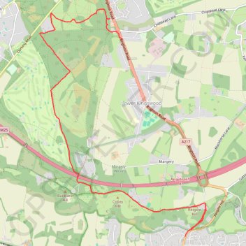
Walk Colley Hill, Banstead Heath
Colley Hill, Banstead Heath, Surrey
- Distance: 5.7 mi
- Elevation gain: 705 ft
- Maximum elevation: 774 ft
- Elevation loss: 630 ft
- Minimum elevation: 440 ft
- Moving time: 2 h 37 m
- Moving speed: 2.2 mph
- Maximum speed: 5.3 mph
- Total time: 3 h 26 m
- Global speed: 1.7 mph
Interactive trail map
Trail profile
- Distance: 5.7 mi
- Elevation gain: 705 ft
- Maximum elevation: 774 ft
- Elevation loss: 630 ft
- Minimum elevation: 440 ft
- Moving time: 2 h 37 m
- Moving speed: 2.2 mph
- Maximum speed: 5.3 mph
- Total time: 3 h 26 m
- Global speed: 1.7 mph
About this trail
Name: Walk Colley Hill, Banstead Heath trail, distance, elevation, map, profile, GPS track
Coordinates: 51.25015 -0.23553 51.28297 -0.19720
Other hiking, mountain biking, running and outdoor activity trails
Click on a trail to view its statistics, map and profile.
Walk Colley Hill, Banstead Heath, Merstham
United Kingdom > England > Surrey > Reigate and Banstead > Reigate
Olley Hill, Banstead Heath, Merstham, Surrey
Distance: 10.5 mi • Elevation gain: 784 ft • Maximum elevation: 774 ft
Walk Tadworth to Merstham
United Kingdom > England > Surrey > Reigate and Banstead > Walton On The Hill
Tadworth, Banstead Heath, Lowert Kingswood, Merstham
Distance: 6.3 mi • Elevation gain: 325 ft • Maximum elevation: 636 ft