Make a donation
Gear up for your next adventure:
As an Amazon Associate, this site earns from qualifying purchases at no extra cost to you.
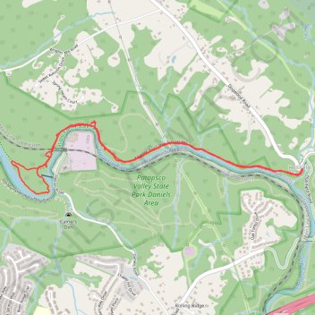
Alberton Road/Thru Trail (white) in Patapsco Valley State Park Daniels Area
- Distance: 3.9 mi
- Elevation gain: 302 ft
- Maximum elevation: 269 ft
- Elevation loss: 302 ft
- Minimum elevation: 207 ft
- Moving time: 1 h 16 m
- Moving speed: 3.1 mph
- Maximum speed: 7.7 mph
- Total time: 1 h 28 m
- Global speed: 2.7 mph
Interactive trail map
Make a donation
Gear up for your next adventure:
As an Amazon Associate, this site earns from qualifying purchases at no extra cost to you.
Trail profile
- Distance: 3.9 mi
- Elevation gain: 302 ft
- Maximum elevation: 269 ft
- Elevation loss: 302 ft
- Minimum elevation: 207 ft
- Moving time: 1 h 16 m
- Moving speed: 3.1 mph
- Maximum speed: 7.7 mph
- Total time: 1 h 28 m
- Global speed: 2.7 mph
Make a donation
Gear up for your next adventure:
As an Amazon Associate, this site earns from qualifying purchases at no extra cost to you.
About this trail
Name: Alberton Road/Thru Trail (white) in Patapsco Valley State Park Daniels Area trail, distance, elevation, map, profile, GPS track
Start: Dogwood Road, Hollifield, Baltimore County, Maryland, 21244, United States (39.31522 -76.79322)
End: Dogwood Road, Hollifield, Baltimore County, Maryland, 21244, United States (39.31531 -76.79331)
Coordinates: 39.31350 -76.81974 39.31864 -76.79322
Topography: Baltimore County topographic map, elevation, terrain
Make a donation
Gear up for your next adventure:
As an Amazon Associate, this site earns from qualifying purchases at no extra cost to you.
Other hiking, mountain biking, running and outdoor activity trails
Click on a trail to view its statistics, map and profile.
Patapsco Valley State Park - Pickall and Hollofield Areas
United States > Maryland > Howard County > Ellicott City
Distance: 6.4 mi • Elevation gain: 906 ft • Maximum elevation: 535 ft