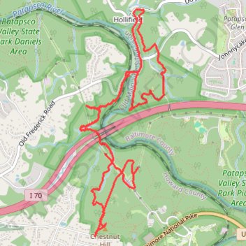
Patapsco Valley State Park - Pickall and Hollofield Areas
- Distance: 6.4 mi
- Elevation gain: 906 ft
- Maximum elevation: 535 ft
- Elevation loss: 906 ft
- Minimum elevation: 207 ft
- Moving time: 1 h 43 m
- Moving speed: 3.7 mph
- Maximum speed: 8.7 mph
- Total time: 1 h 52 m
- Global speed: 3.4 mph
Interactive trail map
Trail profile
- Distance: 6.4 mi
- Elevation gain: 906 ft
- Maximum elevation: 535 ft
- Elevation loss: 906 ft
- Minimum elevation: 207 ft
- Moving time: 1 h 43 m
- Moving speed: 3.7 mph
- Maximum speed: 8.7 mph
- Total time: 1 h 52 m
- Global speed: 3.4 mph
About this trail
Name: Patapsco Valley State Park - Pickall and Hollofield Areas trail, distance, elevation, map, profile, GPS track
Coordinates: 39.29469 -76.79950 39.31634 -76.78900
Topography: Howard County topographic map, elevation, terrain
Other hiking, mountain biking, running and outdoor activity trails
Click on a trail to view its statistics, map and profile.
Alberton Road/Thru Trail (white) in Patapsco Valley State Park Daniels Area
United States > Maryland > Baltimore County > Hollifield
Distance: 3.9 mi • Elevation gain: 302 ft • Maximum elevation: 269 ft
Patapsco Valley State Park - Pickall Area
United States > Maryland > Howard County > Ellicott City
Distance: 3.9 mi • Elevation gain: 459 ft • Maximum elevation: 436 ft