Make a donation
Gear up for your next adventure:
As an Amazon Associate, this site earns from qualifying purchases at no extra cost to you.
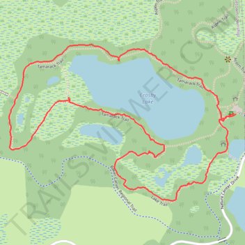
Crosby Lake Loop via Lake Trail and Tamarack Trail
- Distance: 2.0 mi
- Elevation gain: 52 ft
- Maximum elevation: 981 ft
- Elevation loss: 52 ft
- Minimum elevation: 955 ft
- Moving time: 54 m 38 s
- Moving speed: 2.1 mph
- Maximum speed: 4.6 mph
- Total time: 58 m 52 s
- Global speed: 2.0 mph
Interactive trail map
Make a donation
Gear up for your next adventure:
As an Amazon Associate, this site earns from qualifying purchases at no extra cost to you.
Trail profile
- Distance: 2.0 mi
- Elevation gain: 52 ft
- Maximum elevation: 981 ft
- Elevation loss: 52 ft
- Minimum elevation: 955 ft
- Moving time: 54 m 38 s
- Moving speed: 2.1 mph
- Maximum speed: 4.6 mph
- Total time: 58 m 52 s
- Global speed: 2.0 mph
Make a donation
Gear up for your next adventure:
As an Amazon Associate, this site earns from qualifying purchases at no extra cost to you.
About this trail
Name: Crosby Lake Loop via Lake Trail and Tamarack Trail trail, distance, elevation, map, profile, GPS track
Coordinates: 44.87946 -93.69400 44.88457 -93.68351
Topography: Laketown Township topographic map, elevation, terrain
Make a donation
Gear up for your next adventure:
As an Amazon Associate, this site earns from qualifying purchases at no extra cost to you.
Other hiking, mountain biking, running and outdoor activity trails
Click on a trail to view its statistics, map and profile.
Aspen Trail and Tamarack Trail loop around the Crosby Lake
United States > Minnesota > Carver County > Laketown Township
Distance: 2.0 mi • Elevation gain: 75 ft • Maximum elevation: 984 ft