Make a donation
Gear up for your next adventure:
As an Amazon Associate, this site earns from qualifying purchases at no extra cost to you.
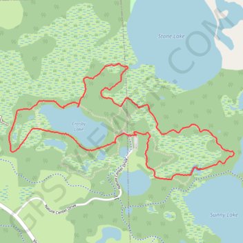
Birding Hike at Carver Park Reserve
Loop hike from Lowry Nature Center via Maple Trail, Dragon Fly Pond, Sunny Lake, Lake Zumbra, Oak Trail, Aspen Trail, Crosby Lake and Tamarack Trail in the Carver Park Reserve. #Hiking #Loop #Nature #Park #Forest #Lake
- Distance: 3.4 mi
- Elevation gain: 164 ft
- Maximum elevation: 984 ft
- Elevation loss: 164 ft
- Minimum elevation: 942 ft
- Moving time: 1 h 25 m
- Moving speed: 2.4 mph
- Maximum speed: 3.5 mph
- Total time: 1 h 46 m
- Global speed: 1.9 mph
Interactive trail map
Make a donation
Gear up for your next adventure:
As an Amazon Associate, this site earns from qualifying purchases at no extra cost to you.
Trail profile
- Distance: 3.4 mi
- Elevation gain: 164 ft
- Maximum elevation: 984 ft
- Elevation loss: 164 ft
- Minimum elevation: 942 ft
- Moving time: 1 h 25 m
- Moving speed: 2.4 mph
- Maximum speed: 3.5 mph
- Total time: 1 h 46 m
- Global speed: 1.9 mph
Make a donation
Gear up for your next adventure:
As an Amazon Associate, this site earns from qualifying purchases at no extra cost to you.
About this trail
Name: Birding Hike at Carver Park Reserve trail, distance, elevation, map, profile, GPS track
Coordinates: 44.87935 -93.69399 44.88692 -93.67331
Topography: Carver County topographic map, elevation, terrain
Make a donation
Gear up for your next adventure:
As an Amazon Associate, this site earns from qualifying purchases at no extra cost to you.
Other hiking, mountain biking, running and outdoor activity trails
Click on a trail to view its statistics, map and profile.
Aspen Trail and Tamarack Trail loop around the Crosby Lake
United States > Minnesota > Carver County > Laketown Township
Distance: 2.0 mi • Elevation gain: 75 ft • Maximum elevation: 984 ft
Crosby Lake Loop via Lake Trail and Tamarack Trail
United States > Minnesota > Carver County > Laketown Township
Distance: 2.0 mi • Elevation gain: 52 ft • Maximum elevation: 981 ft
Maple Trail - Carver Park Reserve
United States > Minnesota > Carver County > Victoria
Distance: 1.4 mi • Elevation gain: 69 ft • Maximum elevation: 978 ft