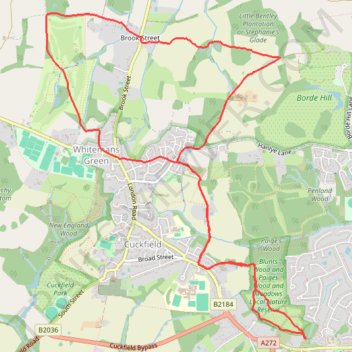
Walk - Haywards Heath, Borde Hill, Cuckfield, Whitemans Green
- Distance: 6.9 mi
- Elevation gain: 614 ft
- Maximum elevation: 417 ft
- Elevation loss: 610 ft
- Minimum elevation: 194 ft
- Moving time: 2 h 18 m
- Moving speed: 3.0 mph
- Maximum speed: 5.4 mph
- Total time: 2 h 34 m
- Global speed: 2.7 mph
Interactive trail map
Trail profile
- Distance: 6.9 mi
- Elevation gain: 614 ft
- Maximum elevation: 417 ft
- Elevation loss: 610 ft
- Minimum elevation: 194 ft
- Moving time: 2 h 18 m
- Moving speed: 3.0 mph
- Maximum speed: 5.4 mph
- Total time: 2 h 34 m
- Global speed: 2.7 mph
About this trail
Name: Walk - Haywards Heath, Borde Hill, Cuckfield, Whitemans Green trail, distance, elevation, map, profile, GPS track
Coordinates: 51.00021 -0.15189 51.02629 -0.11884
Other hiking, mountain biking, running and outdoor activity trails
Click on a trail to view its statistics, map and profile.
Walk - Cuckfield, Bolney
United Kingdom > England > West Sussex > Mid Sussex > Cuckfield
Cuckfield, Bolney
Distance: 9.1 mi • Elevation gain: 745 ft • Maximum elevation: 341 ft
Walk - Haywards Heath, Borde Hill, Brook Street, Cuckfield
United Kingdom > England > West Sussex > Mid Sussex > Haywards Heath
Distance: 7.6 mi • Elevation gain: 646 ft • Maximum elevation: 417 ft
Walk - Handcross, Nymans, Staplefield, Whitmans Green, Cuckfield, Haywards Heath
United Kingdom > England > West Sussex > Mid Sussex > Slaugham
Distance: 7.3 mi • Elevation gain: 531 ft • Maximum elevation: 495 ft
Loop walk - Haywards Heath, Borde Hill, Cuckfield, Whitemans Green
United Kingdom > England > West Sussex > Mid Sussex > Haywards Heath
Distance: 7.6 mi • Elevation gain: 607 ft • Maximum elevation: 417 ft
Walk - Handcross, Cuckfield, Haywards Heath
United Kingdom > England > West Sussex > Mid Sussex > Slaugham
Handcross, Cuckfield, Haywards Heath
Distance: 7.8 mi • Elevation gain: 554 ft • Maximum elevation: 505 ft
Walk - Handcross, Nymans, Staplefield, Whitmans Green, Cuckfield, Haywards Heath
United Kingdom > England > West Sussex > Mid Sussex > Slaugham
Distance: 8.4 mi • Elevation gain: 663 ft • Maximum elevation: 502 ft
Loop Walk - Haywards Heath, Borde Hill, Cuckfield, Whitemans Green
United Kingdom > England > West Sussex > Mid Sussex > Haywards Heath
Distance: 7.9 mi • Elevation gain: 623 ft • Maximum elevation: 417 ft
Walk - Nymans, Handcross, Staplefield, Cuckfield, Haywards Heath
United Kingdom > England > West Sussex > Mid Sussex > Slaugham
Distance: 8.7 mi • Elevation gain: 600 ft • Maximum elevation: 499 ft