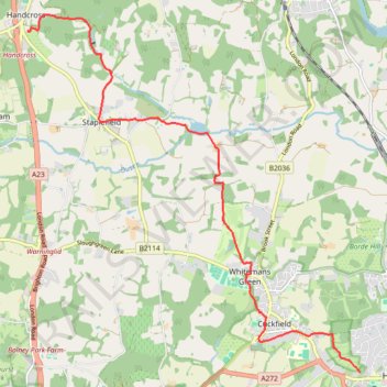
Walk - Handcross, Nymans, Staplefield, Whitmans Green, Cuckfield, Haywards Heath
- Distance: 7.3 mi
- Elevation gain: 531 ft
- Maximum elevation: 495 ft
- Elevation loss: 728 ft
- Minimum elevation: 164 ft
- Moving time: 2 h 52 m
- Moving speed: 2.6 mph
- Maximum speed: 4.6 mph
- Total time: 3 h 28 m
- Global speed: 2.1 mph
Interactive trail map
Trail profile
- Distance: 7.3 mi
- Elevation gain: 531 ft
- Maximum elevation: 495 ft
- Elevation loss: 728 ft
- Minimum elevation: 164 ft
- Moving time: 2 h 52 m
- Moving speed: 2.6 mph
- Maximum speed: 4.6 mph
- Total time: 3 h 28 m
- Global speed: 2.1 mph
About this trail
Name: Walk - Handcross, Nymans, Staplefield, Whitmans Green, Cuckfield, Haywards Heath trail, distance, elevation, map, profile, GPS track
Coordinates: 51.00029 -0.19887 51.05457 -0.11897
Other hiking, mountain biking, running and outdoor activity trails
Click on a trail to view its statistics, map and profile.
Walk - Cuckfield, Bolney
United Kingdom > England > West Sussex > Mid Sussex > Cuckfield
Cuckfield, Bolney
Distance: 9.1 mi • Elevation gain: 745 ft • Maximum elevation: 341 ft
Walk - Haywards Heath, Borde Hill, Brook Street, Cuckfield
United Kingdom > England > West Sussex > Mid Sussex > Haywards Heath
Distance: 7.6 mi • Elevation gain: 646 ft • Maximum elevation: 417 ft
Balcombe to Staplefield Loop
United Kingdom > England > West Sussex > Mid Sussex > Balcombe
Loop hike from Balcombe to Staplefield via Balcombe Recreation Ground, Kemps Farm, Whitethroat Lane, Brantridge Lane, Tanyard Lane, Ditton Place and Westup Road in the High Weald National Landscape. #Hiking #Loop #Countryside #Nature #Forest
Distance: 7.7 mi • Elevation gain: 823 ft • Maximum elevation: 463 ft
Loop walk - Haywards Heath, Borde Hill, Cuckfield, Whitemans Green
United Kingdom > England > West Sussex > Mid Sussex > Haywards Heath
Distance: 7.6 mi • Elevation gain: 607 ft • Maximum elevation: 417 ft
Loop walk around Balcome including Ardingly Reservoir
United Kingdom > England > West Sussex > Mid Sussex > Balcombe
Balcombe, West Sussex, UK
Distance: 6.9 mi • Elevation gain: 630 ft • Maximum elevation: 348 ft
Walk - Handcross, Cuckfield, Haywards Heath
United Kingdom > England > West Sussex > Mid Sussex > Slaugham
Handcross, Cuckfield, Haywards Heath
Distance: 7.8 mi • Elevation gain: 554 ft • Maximum elevation: 505 ft
Walk - Handcross, Nymans, Staplefield, Whitmans Green, Cuckfield, Haywards Heath
United Kingdom > England > West Sussex > Mid Sussex > Slaugham
Distance: 8.4 mi • Elevation gain: 663 ft • Maximum elevation: 502 ft
Loop Walk - Haywards Heath, Borde Hill, Cuckfield, Whitemans Green
United Kingdom > England > West Sussex > Mid Sussex > Haywards Heath
Distance: 7.9 mi • Elevation gain: 623 ft • Maximum elevation: 417 ft
Loop walk - Ardingly Reservoir, Balcombe, Wakehurst Place, Ardingly
United Kingdom > England > West Sussex > Mid Sussex > Ardingly
Distance: 10.4 mi • Elevation gain: 1,079 ft • Maximum elevation: 466 ft
Loop walk via Ardingly Reservoir, Wakehurst Place and Balcombe
United Kingdom > England > West Sussex > Mid Sussex > Ardingly
Distance: 9.1 mi • Elevation gain: 761 ft • Maximum elevation: 456 ft
Walk - Haywards Heath, Borde Hill, Cuckfield, Whitemans Green
United Kingdom > England > West Sussex > Mid Sussex > Haywards Heath
Distance: 6.9 mi • Elevation gain: 614 ft • Maximum elevation: 417 ft
Walk - Ardingly Reservoir, Balcombe, Wakehurst Place
United Kingdom > England > West Sussex > Mid Sussex > Ardingly
Ardingly Reservoir, Balcombe, Wakehurst Place
Distance: 9.1 mi • Elevation gain: 1,010 ft • Maximum elevation: 463 ft
Loop Walk - Bolney, Warninglid
United Kingdom > England > West Sussex > Mid Sussex > Bolney
Bolney, Warninglid
Distance: 12.0 mi • Elevation gain: 997 ft • Maximum elevation: 397 ft
Walk - Balcombe, Ouse Valley, Ardingly
United Kingdom > England > West Sussex > Mid Sussex > Balcombe
Distance: 11.0 mi • Elevation gain: 997 ft • Maximum elevation: 427 ft
Walk - Balcombe, Wakehurst, Ardingly
United Kingdom > England > West Sussex > Mid Sussex > Balcombe
Distance: 9.4 mi • Elevation gain: 892 ft • Maximum elevation: 459 ft
Walk - Balcombe, Staplefield
United Kingdom > England > West Sussex > Mid Sussex > Balcombe
Distance: 8.1 mi • Elevation gain: 866 ft • Maximum elevation: 463 ft
Loop Walk - Balcombe
United Kingdom > England > West Sussex > Mid Sussex > Balcombe
Distance: 4.9 mi • Elevation gain: 541 ft • Maximum elevation: 466 ft
Walk - Nymans, Handcross, Staplefield, Cuckfield, Haywards Heath
United Kingdom > England > West Sussex > Mid Sussex > Slaugham
Distance: 8.7 mi • Elevation gain: 600 ft • Maximum elevation: 499 ft