Mountain Bike Ride around Craigvinean Forest
UK, Perthshire, Dunkeld
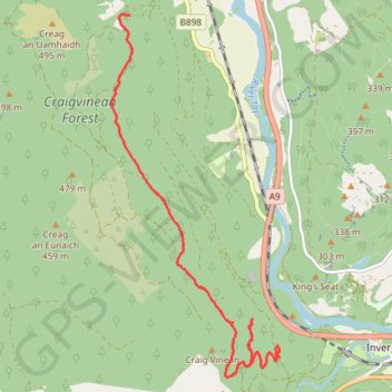
- Distance: 4.8 mi
- Elevation gain: 1,076 ft
- Maximum elevation: 1,096 ft
- Elevation loss: 495 ft
- Minimum elevation: 371 ft
- Moving time: 46 m 30 s
- Moving speed: 6.2 mph
- Maximum speed: 26.5 mph
- Total time: 1 h 13 m
- Global speed: 3.9 mph
Interactive trail map
Trail profile
- Distance: 4.8 mi
- Elevation gain: 1,076 ft
- Maximum elevation: 1,096 ft
- Elevation loss: 495 ft
- Minimum elevation: 371 ft
- Moving time: 46 m 30 s
- Moving speed: 6.2 mph
- Maximum speed: 26.5 mph
- Total time: 1 h 13 m
- Global speed: 3.9 mph
About this trail
Name: Mountain Bike Ride around Craigvinean Forest trail, distance, elevation, map, profile, GPS track
Start: A9, Inver, Perth and Kinross, Scotland, PH8 0JR, United Kingdom (56.55991 -3.62052)
End: Dalguise, Perth and Kinross, Scotland, PH8 0JU, United Kingdom (56.59534 -3.64842)
Coordinates: 56.55795 -3.65193 56.59544 -3.62041
Other hiking, mountain biking, running and outdoor activity trails
Click on a trail to view its statistics, map and profile.
Loop from The Hermitage to Craigvinean Forest Ruins
United Kingdom > Scotland > Perth and Kinross > Inver
Distance: 12.5 mi • Elevation gain: 1,926 ft • Maximum elevation: 1,526 ft
EMTB Gravel: Murthly - Birnam - Loop
United Kingdom > Scotland > Perth and Kinross > Newlands
Around Dunkeld, Perthshire Scotland
Distance: 28.8 mi • Elevation gain: 2,851 ft • Maximum elevation: 1,001 ft
Falls of the Braan and River Tay loop trail
United Kingdom > Scotland > Perth and Kinross > Dunkeld > Inchmagrannachan
Distance: 6.8 mi • Elevation gain: 768 ft • Maximum elevation: 610 ft
Walk over A9 bridge over River Braan by pedestrian pavement (sidewalk) and small diversion for SGN gas pipeline route then Fiddlers path
United Kingdom > Scotland > Perth and Kinross > Dunkeld
Distance: 3.7 mi • Elevation gain: 259 ft • Maximum elevation: 249 ft
Craigvinean Forest Loop MTB, Dunkeld, Perthshire
United Kingdom > Scotland > Perth and Kinross > Inver
Mountain Bike Ride, UK, Perthshire, Dunkeld
Distance: 13.3 mi • Elevation gain: 1,844 ft • Maximum elevation: 1,188 ft