Make a donation
Gear up for your next adventure:
As an Amazon Associate, this site earns from qualifying purchases at no extra cost to you.
Chasm Lake via East Longs Peak Trail and Chasm Lake Trail
The hike to Chasm Lake in Rocky Mountain National Park is a rewarding journey through diverse alpine landscapes. Starting from the Longs Peak Trailhead, the trail gradually ascends through a dense forest of spruce and pine before breaking above the treeline, where sweeping views of Mount Meeker, Mount Lady Washington, and the famed Diamond Face of Longs Peak emerge. As you approach the lake, the trail offers glimpses of cascading waterfalls and the striking Peacock Pool, culminating in the serene beauty of Chasm Lake nestled amidst rugged cliffs and dramatic peaks. #Hiking #Mountain #Forest #Nature #Lake #Waterfall
- Distance: 8.1 mi
- Elevation gain: 2,575 ft
- Maximum elevation: 11,814 ft
- Elevation loss: 2,575 ft
- Minimum elevation: 9,377 ft
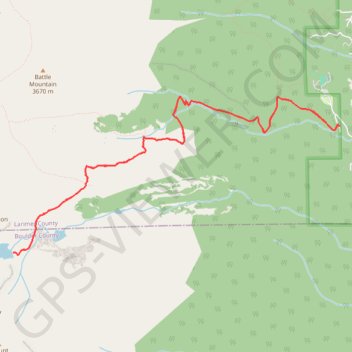
Interactive trail map
Make a donation
Gear up for your next adventure:
As an Amazon Associate, this site earns from qualifying purchases at no extra cost to you.
Trail profile
- Distance: 8.1 mi
- Elevation gain: 2,575 ft
- Maximum elevation: 11,814 ft
- Elevation loss: 2,575 ft
- Minimum elevation: 9,377 ft
Make a donation
Gear up for your next adventure:
As an Amazon Associate, this site earns from qualifying purchases at no extra cost to you.
About this trail
Name: Chasm Lake via East Longs Peak Trail and Chasm Lake Trail trail, distance, elevation, map, profile, GPS track
Start: Longs Peak Trailhead, Longs Peak Road, Larimer County, Colorado, United States (40.27206 -105.55650)
End: Longs Peak Trailhead, Longs Peak Road, Larimer County, Colorado, United States (40.27209 -105.55650)
Coordinates: 40.25809 -105.60289 40.27526 -105.55650
Topography: Larimer County topographic map, elevation, terrain
Make a donation
Gear up for your next adventure:
As an Amazon Associate, this site earns from qualifying purchases at no extra cost to you.
Other hiking, mountain biking, running and outdoor activity trails
Click on a trail to view its statistics, map and profile.