Mount Hancock via Hancock Notch Trail and Hancock Loop Trail
The hike to Mount Hancock, Middle Hancock and South Hancock is a scenic journey through the White Mountain National Forest, offering lush forests and rewarding viewpoints. The initial stretch along the Hancock Notch Trail is a gentle introduction with stream crossings and serene woodlands, transitioning into steeper climbs as you ascend. While summits are wooded, nearby overlooks reveal sweeping views of the Sandwich Range and surrounding wilderness, making the effort worthwhile despite the rugged terrain and loose footing in sections. #Hiking #Mountain #Forest #Nature #Loop
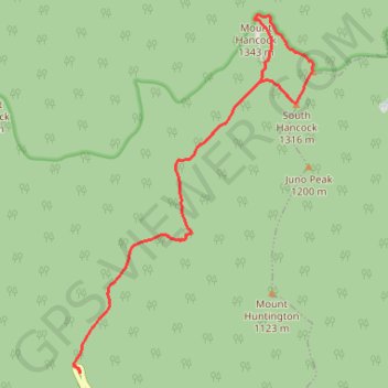
- Distance: 9.2 mi
- Elevation gain: 2,549 ft
- Maximum elevation: 4,357 ft
- Elevation loss: 2,549 ft
- Minimum elevation: 2,116 ft
Interactive trail map
Trail profile
- Distance: 9.2 mi
- Elevation gain: 2,549 ft
- Maximum elevation: 4,357 ft
- Elevation loss: 2,549 ft
- Minimum elevation: 2,116 ft
About this trail
Name: Mount Hancock via Hancock Notch Trail and Hancock Loop Trail trail, distance, elevation, map, profile, GPS track
Coordinates: 44.04066 -71.52442 44.08408 -71.48401
Topography: Grafton County topographic map, elevation, terrain
Other hiking, mountain biking, running and outdoor activity trails
Click on a trail to view its statistics, map and profile.