Thank you for supporting this site ❤️
Make a donation
Make a donation
Gear up for your next adventure:
As an Amazon Associate, this site earns from qualifying purchases at no extra cost to you.
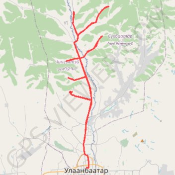
Зуслан чэллэнж
- Distance: 49.2 mi
- Elevation gain: 4,364 ft
- Maximum elevation: 5,361 ft
- Elevation loss: 4,347 ft
- Minimum elevation: 4,278 ft
Interactive trail map
Thank you for supporting this site ❤️
Make a donation
Make a donation
Gear up for your next adventure:
As an Amazon Associate, this site earns from qualifying purchases at no extra cost to you.
Trail profile
- Distance: 49.2 mi
- Elevation gain: 4,364 ft
- Maximum elevation: 5,361 ft
- Elevation loss: 4,347 ft
- Minimum elevation: 4,278 ft
Thank you for supporting this site ❤️
Make a donation
Make a donation
Gear up for your next adventure:
As an Amazon Associate, this site earns from qualifying purchases at no extra cost to you.
About this trail
Name: Зуслан чэллэнж trail, distance, elevation, map, profile, GPS track
Start: Санзайн зам, Chingeltei, Ulaanbaatar, Mongolia (48.04020 106.90464)
End: Chingeltei, Ulaanbaatar, Mongolia (48.04036 106.90333)
Coordinates: 47.92586 106.88819 48.08472 106.95072
Thank you for supporting this site ❤️
Make a donation
Make a donation
Gear up for your next adventure:
As an Amazon Associate, this site earns from qualifying purchases at no extra cost to you.
Other hiking, mountain biking, running and outdoor activity trails
Click on a trail to view its statistics, map and profile.
UDA 7 davaa challenge
Distance: 84.0 mi • Elevation gain: 8,474 ft • Maximum elevation: 6,611 ft