Make a donation
Gear up for your next adventure:
As an Amazon Associate, this site earns from qualifying purchases at no extra cost to you.
UDA 7 davaa challenge
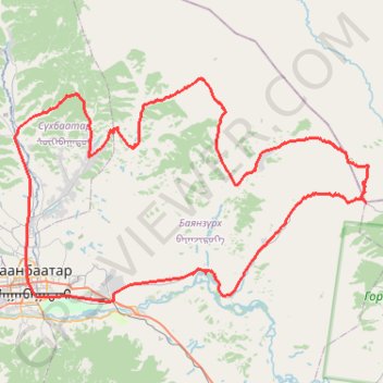
- Distance: 84.0 mi
- Elevation gain: 8,474 ft
- Maximum elevation: 6,611 ft
- Elevation loss: 8,471 ft
- Minimum elevation: 4,229 ft
Interactive trail map
Make a donation
Gear up for your next adventure:
As an Amazon Associate, this site earns from qualifying purchases at no extra cost to you.
Trail profile
- Distance: 84.0 mi
- Elevation gain: 8,474 ft
- Maximum elevation: 6,611 ft
- Elevation loss: 8,471 ft
- Minimum elevation: 4,229 ft
Make a donation
Gear up for your next adventure:
As an Amazon Associate, this site earns from qualifying purchases at no extra cost to you.
About this trail
Name: UDA 7 davaa challenge trail, distance, elevation, map, profile, GPS track
Start: Great Mongolian Empire Street, Bayanzürkh, Ulaanbaatar, 17010, Mongolia (47.90511 106.92811)
End: Хүннүгийн гудамж, Bayanzürkh, Ulaanbaatar, 13312, Mongolia (47.90444 106.93060)
Coordinates: 47.89846 106.90011 48.10148 107.37750
Make a donation
Gear up for your next adventure:
As an Amazon Associate, this site earns from qualifying purchases at no extra cost to you.
Other hiking, mountain biking, running and outdoor activity trails
Click on a trail to view its statistics, map and profile.
A century solo ride - clockwise cycling the Bogd mountain #PowerMap #StatMaps
Distance: 65.8 mi • Elevation gain: 3,432 ft • Maximum elevation: 5,482 ft
Зуслан чэллэнж
Distance: 49.2 mi • Elevation gain: 4,364 ft • Maximum elevation: 5,361 ft
A century solo ride - clockwise cycling the Bogd mountain #PowerMap #StatMaps
Distance: 65.8 mi • Elevation gain: 3,432 ft • Maximum elevation: 5,482 ft