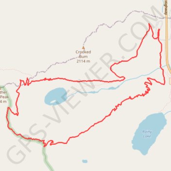
Maple Pass Trail around Lake Ann in Okanogan-Wenatchee National Forest
The Maple Pass Loop Trail offers an enchanting journey through the heart of the North Cascades, where the air is crisp and the scenery is nothing short of breathtaking. As you meander along the path, you’ll be captivated by sweeping vistas of jagged mountain peaks, vibrant wildflower meadows, and the serene beauty of Lake Ann nestled in its alpine setting. This trail is a true gem, inviting you to embrace the tranquility of nature while creating unforgettable memories with each step you take. #Hiking #Loop #Mountain #Lake #Forest #Nature
- Distance: 7.0 mi
- Elevation gain: 2,349 ft
- Maximum elevation: 6,936 ft
- Elevation loss: 2,352 ft
- Minimum elevation: 4,852 ft
- Moving time: 4 h 9 m
- Moving speed: 1.7 mph
- Maximum speed: 7.2 mph
- Total time: 5 h 25 m
- Global speed: 1.3 mph
Interactive trail map
Trail profile
- Distance: 7.0 mi
- Elevation gain: 2,349 ft
- Maximum elevation: 6,936 ft
- Elevation loss: 2,352 ft
- Minimum elevation: 4,852 ft
- Moving time: 4 h 9 m
- Moving speed: 1.7 mph
- Maximum speed: 7.2 mph
- Total time: 5 h 25 m
- Global speed: 1.3 mph
About this trail
Name: Maple Pass Trail around Lake Ann in Okanogan-Wenatchee National Forest trail, distance, elevation, map, profile, GPS track
Start: Rainy Pass Picnic Area, Chelan County, Washington, United States (48.51618 -120.73574)
End: Rainy Pass Picnic Area, Chelan County, Washington, United States (48.51623 -120.73558)
Coordinates: 48.49906 -120.76939 48.51714 -120.73438
Topography: Chelan County topographic map, elevation, terrain
Other hiking, mountain biking, running and outdoor activity trails
Click on a trail to view its statistics, map and profile.
Maple Pass Loop Trail in Okanogan-Wenatchee National Forest
United States > Washington > Chelan County
The Maple Pass Loop Trail offers an unforgettable hiking experience in the North Cascades, showcasing a blend of lush forests, serene alpine lakes, deep valleys, and expansive mountain vistas, making it a must-see for outdoor enthusiasts. Hikers often marvel at the views of Lake Ann from above, framed by…
Distance: 6.5 mi • Elevation gain: 2,323 ft • Maximum elevation: 6,932 ft
Northern part of the Pacific Crest Trail (PCT)
United States > Oregon > Klamath County
Hike on the Pacific Crest National Scenic Trail from Crater Lake to Canada Border through Oregon and Washington along the Sierra Nevada and Cascade mountain ranges. #Hiking #Mountain #SierraNevada #Cascade #Nature #Forest #Park #PCT
Distance: 744.6 mi • Elevation gain: 145,367 ft • Maximum elevation: 7,569 ft