Maple Pass Loop Trail in Okanogan-Wenatchee National Forest
The Maple Pass Loop Trail offers an unforgettable hiking experience in the North Cascades, showcasing a blend of lush forests, serene alpine lakes, deep valleys, and expansive mountain vistas, making it a must-see for outdoor enthusiasts. Hikers often marvel at the views of Lake Ann from above, framed by jagged peaks and meadows teeming with wildflowers or golden larches, depending on the season. The trail also offers dramatic mountain panoramas with peaks like Black Peak and Goode Mountain punctuating the horizon. #Hiking #Mountain #Forest #Nature #Loop #Lake #Overlook
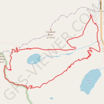
- Distance: 6.5 mi
- Elevation gain: 2,323 ft
- Maximum elevation: 6,932 ft
- Elevation loss: 2,323 ft
- Minimum elevation: 4,852 ft
Interactive trail map
Trail profile
- Distance: 6.5 mi
- Elevation gain: 2,323 ft
- Maximum elevation: 6,932 ft
- Elevation loss: 2,323 ft
- Minimum elevation: 4,852 ft
About this trail
Name: Maple Pass Loop Trail in Okanogan-Wenatchee National Forest trail, distance, elevation, map, profile, GPS track
Start: Rainy Lake Trail, Chelan County, Washington, United States (48.51518 -120.73585)
End: Rainy Lake Trail, Chelan County, Washington, United States (48.51512 -120.73583)
Coordinates: 48.49919 -120.76938 48.51722 -120.73433
Topography: Chelan County topographic map, elevation, terrain
Other hiking, mountain biking, running and outdoor activity trails
Click on a trail to view its statistics, map and profile.
Maple Pass Trail around Lake Ann in Okanogan-Wenatchee National Forest
United States > Washington > Chelan County
The Maple Pass Loop Trail offers an enchanting journey through the heart of the North Cascades, where the air is crisp and the scenery is nothing short of breathtaking. As you meander along the path, you’ll be captivated by sweeping vistas of jagged mountain peaks, vibrant wildflower meadows, and the serene…
Distance: 7.0 mi • Elevation gain: 2,349 ft • Maximum elevation: 6,936 ft
Northern part of the Pacific Crest Trail (PCT)
United States > Oregon > Klamath County
Hike on the Pacific Crest National Scenic Trail from Crater Lake to Canada Border through Oregon and Washington along the Sierra Nevada and Cascade mountain ranges. #Hiking #Mountain #SierraNevada #Cascade #Nature #Forest #Park #PCT
Distance: 744.6 mi • Elevation gain: 145,367 ft • Maximum elevation: 7,569 ft