Make a donation
Gear up for your next adventure:
As an Amazon Associate, this site earns from qualifying purchases at no extra cost to you.
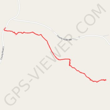
Whitaker Point Trail to Hawksbill Crag in Ozark-St. Francis National Forest
The Whitaker Point Trail offers a captivating journey through the lush landscapes of the Ozark-St. Francis National Forest, leading to the iconic Hawksbill Crag. Hikers will experience a variety of natural features, including dense forests, rocky outcrops, and stunning panoramic views of the surrounding mountains and valleys. This moderately challenging route rewards adventurers with a serene escape into nature, making it an ideal destination for those seeking both tranquility and breathtaking scenery. #Hiking #River #Forest #Nature #Overlook
- Distance: 2.7 mi
- Elevation gain: 456 ft
- Maximum elevation: 2,195 ft
- Elevation loss: 449 ft
- Minimum elevation: 1,873 ft
- Moving time: 56 m 42 s
- Moving speed: 2.8 mph
- Maximum speed: 6.5 mph
- Total time: 1 h 1 m
- Global speed: 2.6 mph
Interactive trail map
Make a donation
Gear up for your next adventure:
As an Amazon Associate, this site earns from qualifying purchases at no extra cost to you.
Trail profile
- Distance: 2.7 mi
- Elevation gain: 456 ft
- Maximum elevation: 2,195 ft
- Elevation loss: 449 ft
- Minimum elevation: 1,873 ft
- Moving time: 56 m 42 s
- Moving speed: 2.8 mph
- Maximum speed: 6.5 mph
- Total time: 1 h 1 m
- Global speed: 2.6 mph
Make a donation
Gear up for your next adventure:
As an Amazon Associate, this site earns from qualifying purchases at no extra cost to you.
About this trail
Name: Whitaker Point Trail to Hawksbill Crag in Ozark-St. Francis National Forest trail, distance, elevation, map, profile, GPS track
Start: County Road 5, Ryker, Newton County, Arkansas, United States (35.89856 -93.45772)
End: Whitaker Point Trail, Newton County, Arkansas, United States (35.89822 -93.45797)
Coordinates: 35.89076 -93.45798 35.89856 -93.44010
Topography: Newton County topographic map, elevation, terrain
Make a donation
Gear up for your next adventure:
As an Amazon Associate, this site earns from qualifying purchases at no extra cost to you.
Other hiking, mountain biking, running and outdoor activity trails
Click on a trail to view its statistics, map and profile.