Make a donation
Gear up for your next adventure:
As an Amazon Associate, this site earns from qualifying purchases at no extra cost to you.
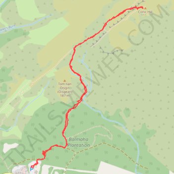
Walking trail from Balmaha to summit of Conic Hill via West Highland Way - Slighe Taobh an Iar na Gàidhealtachd
- Distance: 2.9 mi
- Elevation gain: 1,043 ft
- Maximum elevation: 1,112 ft
- Elevation loss: 1,076 ft
- Minimum elevation: 72 ft
- Moving time: 1 h 23 m
- Moving speed: 2.1 mph
- Maximum speed: 41.3 mph
- Total time: 2 h 7 m
- Global speed: 1.4 mph
Interactive trail map
Make a donation
Gear up for your next adventure:
As an Amazon Associate, this site earns from qualifying purchases at no extra cost to you.
Trail profile
- Distance: 2.9 mi
- Elevation gain: 1,043 ft
- Maximum elevation: 1,112 ft
- Elevation loss: 1,076 ft
- Minimum elevation: 72 ft
- Moving time: 1 h 23 m
- Moving speed: 2.1 mph
- Maximum speed: 41.3 mph
- Total time: 2 h 7 m
- Global speed: 1.4 mph
Make a donation
Gear up for your next adventure:
As an Amazon Associate, this site earns from qualifying purchases at no extra cost to you.
About this trail
Name: Walking trail from Balmaha to summit of Conic Hill via West Highland Way - Slighe Taobh an Iar na Gàidhealtachd trail, distance, elevation, map, profile, GPS track
Coordinates: 56.08537 -4.53955 56.09718 -4.52483
Make a donation
Gear up for your next adventure:
As an Amazon Associate, this site earns from qualifying purchases at no extra cost to you.
Other hiking, mountain biking, running and outdoor activity trails
Click on a trail to view its statistics, map and profile.
Conic Hill
United Kingdom > Scotland > Stirling > Balmaha > Arrochymore
Distance: 4.2 mi • Elevation gain: 1,204 ft • Maximum elevation: 1,152 ft