Make a donation
Gear up for your next adventure:
As an Amazon Associate, this site earns from qualifying purchases at no extra cost to you.
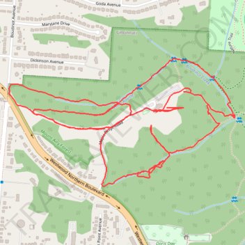
Mount Airy Forest Maple Ridge Area
- Distance: 3.4 mi
- Elevation gain: 226 ft
- Maximum elevation: 892 ft
- Elevation loss: 262 ft
- Minimum elevation: 804 ft
- Moving time: 1 h 17 m
- Moving speed: 2.6 mph
- Maximum speed: 10.0 mph
- Total time: 1 h 24 m
- Global speed: 2.4 mph
Interactive trail map
Make a donation
Gear up for your next adventure:
As an Amazon Associate, this site earns from qualifying purchases at no extra cost to you.
Trail profile
- Distance: 3.4 mi
- Elevation gain: 226 ft
- Maximum elevation: 892 ft
- Elevation loss: 262 ft
- Minimum elevation: 804 ft
- Moving time: 1 h 17 m
- Moving speed: 2.6 mph
- Maximum speed: 10.0 mph
- Total time: 1 h 24 m
- Global speed: 2.4 mph
Make a donation
Gear up for your next adventure:
As an Amazon Associate, this site earns from qualifying purchases at no extra cost to you.
About this trail
Name: Mount Airy Forest Maple Ridge Area trail, distance, elevation, map, profile, GPS track
Coordinates: 39.15940 -84.60190 39.16420 -84.59094
Topography: Cincinnati topographic map, elevation, terrain
Make a donation
Gear up for your next adventure:
As an Amazon Associate, this site earns from qualifying purchases at no extra cost to you.
Other hiking, mountain biking, running and outdoor activity trails
Click on a trail to view its statistics, map and profile.
Mount Airy Forest Bicentennial Park Area
United States > Ohio > Hamilton County
Distance: 4.7 mi • Elevation gain: 482 ft • Maximum elevation: 873 ft
Mount Airy Forest loop walk
United States > Ohio > Hamilton County > Cincinnati
Distance: 3.3 mi • Elevation gain: 364 ft • Maximum elevation: 873 ft