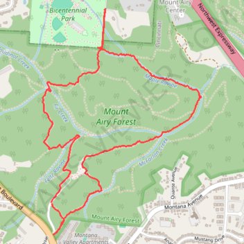
Mount Airy Forest loop walk
- Distance: 3.3 mi
- Elevation gain: 364 ft
- Maximum elevation: 873 ft
- Elevation loss: 364 ft
- Minimum elevation: 676 ft
- Moving time: 1 h 22 m
- Moving speed: 2.4 mph
- Maximum speed: 7.4 mph
- Total time: 1 h 31 m
- Global speed: 2.1 mph
Interactive trail map
Trail profile
- Distance: 3.3 mi
- Elevation gain: 364 ft
- Maximum elevation: 873 ft
- Elevation loss: 364 ft
- Minimum elevation: 676 ft
- Moving time: 1 h 22 m
- Moving speed: 2.4 mph
- Maximum speed: 7.4 mph
- Total time: 1 h 31 m
- Global speed: 2.1 mph
About this trail
Name: Mount Airy Forest loop walk trail, distance, elevation, map, profile, GPS track
Coordinates: 39.15343 -84.59124 39.16653 -84.57938
Topography: Cincinnati topographic map, elevation, terrain
Other hiking, mountain biking, running and outdoor activity trails
Click on a trail to view its statistics, map and profile.
Mount Airy Forest Bicentennial Park Area
United States > Ohio > Hamilton County
Distance: 4.7 mi • Elevation gain: 482 ft • Maximum elevation: 873 ft
Mount Airy Forest Maple Ridge Area
United States > Ohio > Hamilton County > Cincinnati
Distance: 3.4 mi • Elevation gain: 226 ft • Maximum elevation: 892 ft