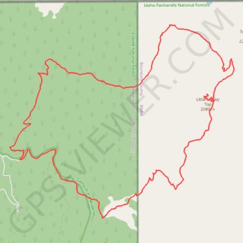
Little Snowy Top via Salmo-Priest Loop
Morning hike at Salmo-Priest Loop
- Distance: 19.4 mi
- Elevation gain: 4,603 ft
- Maximum elevation: 6,795 ft
- Elevation loss: 4,587 ft
- Minimum elevation: 4,072 ft
- Moving time: 7 h 35 m
- Moving speed: 2.6 mph
- Maximum speed: 15.5 mph
- Total time: 23 h 27 m
- Global speed: 0.8 mph
Interactive trail map
Trail profile
- Distance: 19.4 mi
- Elevation gain: 4,603 ft
- Maximum elevation: 6,795 ft
- Elevation loss: 4,587 ft
- Minimum elevation: 4,072 ft
- Moving time: 7 h 35 m
- Moving speed: 2.6 mph
- Maximum speed: 15.5 mph
- Total time: 23 h 27 m
- Global speed: 0.8 mph
About this trail
Name: Little Snowy Top via Salmo-Priest Loop trail, distance, elevation, map, profile, GPS track
Start: Sullivan Creek Road, Pend Oreille County, Washington, United States (48.95580 -117.08100)
End: Sullivan Creek Road, Pend Oreille County, Washington, United States (48.95555 -117.08113)
Coordinates: 48.93968 -117.08579 48.99275 -116.99195
Topography: Pend Oreille County topographic map, elevation, terrain
Other hiking, mountain biking, running and outdoor activity trails
Click on a trail to view its statistics, map and profile.
Salmo-Priest Loop
United States > Washington > Pend Oreille County
Distance: 18.6 mi • Elevation gain: 4,514 ft • Maximum elevation: 6,447 ft