Salmo-Priest Loop
- Distance: 18.6 mi
- Elevation gain: 4,514 ft
- Maximum elevation: 6,447 ft
- Elevation loss: 4,488 ft
- Minimum elevation: 4,075 ft
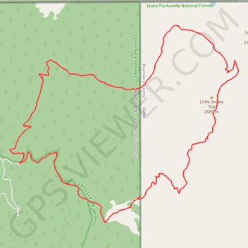
Interactive trail map
Trail profile
- Distance: 18.6 mi
- Elevation gain: 4,514 ft
- Maximum elevation: 6,447 ft
- Elevation loss: 4,488 ft
- Minimum elevation: 4,075 ft
About this trail
Name: Salmo-Priest Loop trail, distance, elevation, map, profile, GPS track
Start: Salmo Basin Trail, Pend Oreille County, Washington, United States (48.95588 -117.08121)
End: Sullivan Creek Road, Pend Oreille County, Washington, United States (48.95559 -117.08096)
Coordinates: 48.93968 -117.08578 48.99271 -116.99181
Topography: Pend Oreille County topographic map, elevation, terrain
Other hiking, mountain biking, running and outdoor activity trails
Click on a trail to view its statistics, map and profile.
Little Snowy Top via Salmo-Priest Loop
United States > Washington > Pend Oreille County
Morning hike at Salmo-Priest Loop
Distance: 19.4 mi • Elevation gain: 4,603 ft • Maximum elevation: 6,795 ft