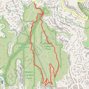
Runyon Canyon Loop
Interactive trail map
Trail profile
- Distance: 3.1 mi
- Elevation gain: 853 ft
- Maximum elevation: 1,250 ft
- Elevation loss: 853 ft
- Minimum elevation: 587 ft
- Moving time: 1 h 20 m
- Moving speed: 2.3 mph
- Maximum speed: 3.5 mph
- Total time: 1 h 28 m
- Global speed: 2.1 mph
About this trail
Name: Runyon Canyon Loop trail, distance, elevation, map, profile, GPS track
Coordinates: 34.10542 -118.35379 34.11912 -118.34799
Topography: Los Angeles topographic map, elevation, terrain
Other hiking, mountain biking, running and outdoor activity trails
Click on a trail to view its statistics, map and profile.
Runyon Canyon Park Loop via West and East Trails
United States > California > Los Angeles County > Los Angeles
The Runyon Canyon Park Loop via West and East Trails offers hikers panoramic views of Los Angeles, including the iconic Hollywood Sign and the sprawling cityscape. Along the trail, visitors can observe native flora such as black sage and California sagebrush, and may encounter local wildlife like hawks and…
Distance: 2.7 mi • Elevation gain: 768 ft • Maximum elevation: 1,257 ft