Make a donation
Gear up for your next adventure:
As an Amazon Associate, this site earns from qualifying purchases at no extra cost to you.
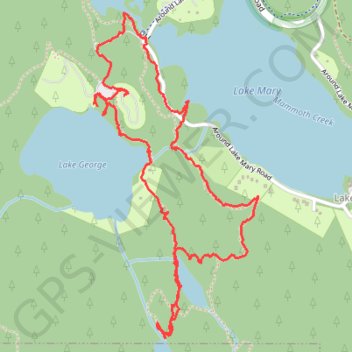
Mammoth Lakes Loop
Loop hike via Lake Mary, Lake Barret, T J Lake, Lake George, Lake Mamie and Mammoth Creek in the Inyo National Forest. #Hiking #Loop #Lake #Forest #Nature #River #Mountain
- Distance: 3.3 mi
- Elevation gain: 522 ft
- Maximum elevation: 9,324 ft
- Elevation loss: 512 ft
- Minimum elevation: 8,907 ft
- Moving time: 1 h 18 m
- Moving speed: 2.6 mph
- Maximum speed: 22.8 mph
- Total time: 1 h 39 m
- Global speed: 2.0 mph
Interactive trail map
Make a donation
Gear up for your next adventure:
As an Amazon Associate, this site earns from qualifying purchases at no extra cost to you.
Trail profile
- Distance: 3.3 mi
- Elevation gain: 522 ft
- Maximum elevation: 9,324 ft
- Elevation loss: 512 ft
- Minimum elevation: 8,907 ft
- Moving time: 1 h 18 m
- Moving speed: 2.6 mph
- Maximum speed: 22.8 mph
- Total time: 1 h 39 m
- Global speed: 2.0 mph
Make a donation
Gear up for your next adventure:
As an Amazon Associate, this site earns from qualifying purchases at no extra cost to you.
About this trail
Name: Mammoth Lakes Loop trail, distance, elevation, map, profile, GPS track
Coordinates: 37.59359 -119.01148 37.60622 -119.00340
Topography: Mono County topographic map, elevation, terrain
Make a donation
Gear up for your next adventure:
As an Amazon Associate, this site earns from qualifying purchases at no extra cost to you.
Other hiking, mountain biking, running and outdoor activity trails
Click on a trail to view its statistics, map and profile.
Gravel bike ride around Mammoth Lakes
United States > California > Mono County
Distance: 33.8 mi • Elevation gain: 3,406 ft • Maximum elevation: 8,986 ft