Make a donation
Gear up for your next adventure:
As an Amazon Associate, this site earns from qualifying purchases at no extra cost to you.
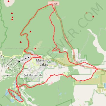
Gravel bike ride around Mammoth Lakes
- Distance: 33.8 mi
- Elevation gain: 3,406 ft
- Maximum elevation: 8,986 ft
- Elevation loss: 3,406 ft
- Minimum elevation: 7,172 ft
- Moving time: 3 h 27 m
- Moving speed: 9.8 mph
- Maximum speed: 44.0 mph
- Total time: 4 h 21 m
- Global speed: 7.8 mph
Interactive trail map
Make a donation
Gear up for your next adventure:
As an Amazon Associate, this site earns from qualifying purchases at no extra cost to you.
Trail profile
- Distance: 33.8 mi
- Elevation gain: 3,406 ft
- Maximum elevation: 8,986 ft
- Elevation loss: 3,406 ft
- Minimum elevation: 7,172 ft
- Moving time: 3 h 27 m
- Moving speed: 9.8 mph
- Maximum speed: 44.0 mph
- Total time: 4 h 21 m
- Global speed: 7.8 mph
Make a donation
Gear up for your next adventure:
As an Amazon Associate, this site earns from qualifying purchases at no extra cost to you.
About this trail
Name: Gravel bike ride around Mammoth Lakes trail, distance, elevation, map, profile, GPS track
Coordinates: 37.59875 -119.01729 37.70866 -118.89063
Topography: Mono County topographic map, elevation, terrain
Make a donation
Gear up for your next adventure:
As an Amazon Associate, this site earns from qualifying purchases at no extra cost to you.
Other hiking, mountain biking, running and outdoor activity trails
Click on a trail to view its statistics, map and profile.
Mammoth to Bridgeport
United States > California > Mono County > Mammoth Lakes
Northern California Backcountry Discovery Route (CABDR-North)
Distance: 94.8 mi • Elevation gain: 7,188 ft • Maximum elevation: 9,259 ft