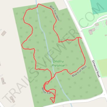
Onatru Preserve Loop Trail
- Distance: 0.8 mi
- Elevation gain: 30 ft
- Maximum elevation: 715 ft
- Elevation loss: 30 ft
- Minimum elevation: 686 ft
- Moving time: 18 m 7 s
- Moving speed: 2.7 mph
- Maximum speed: 4.8 mph
- Total time: 18 m 7 s
- Global speed: 2.7 mph
Interactive trail map
Trail profile
- Distance: 0.8 mi
- Elevation gain: 30 ft
- Maximum elevation: 715 ft
- Elevation loss: 30 ft
- Minimum elevation: 686 ft
- Moving time: 18 m 7 s
- Moving speed: 2.7 mph
- Maximum speed: 4.8 mph
- Total time: 18 m 7 s
- Global speed: 2.7 mph
About this trail
Name: Onatru Preserve Loop Trail trail, distance, elevation, map, profile, GPS track
Coordinates: 41.23968 -73.52033 41.24310 -73.51743
Topography: Westchester County topographic map, elevation, terrain
Other hiking, mountain biking, running and outdoor activity trails
Click on a trail to view its statistics, map and profile.