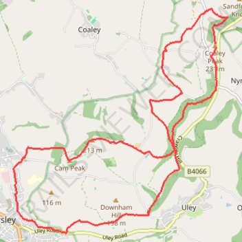
Coaley to Dursley loop walk
- Distance: 10.2 mi
- Elevation gain: 1,814 ft
- Maximum elevation: 797 ft
- Elevation loss: 1,821 ft
- Minimum elevation: 184 ft
- Moving time: 3 h 49 m
- Moving speed: 2.7 mph
- Maximum speed: 12.1 mph
- Total time: 4 h 42 m
- Global speed: 2.2 mph
Interactive trail map
Trail profile
- Distance: 10.2 mi
- Elevation gain: 1,814 ft
- Maximum elevation: 797 ft
- Elevation loss: 1,821 ft
- Minimum elevation: 184 ft
- Moving time: 3 h 49 m
- Moving speed: 2.7 mph
- Maximum speed: 12.1 mph
- Total time: 4 h 42 m
- Global speed: 2.2 mph
About this trail
Name: Coaley to Dursley loop walk trail, distance, elevation, map, profile, GPS track
Coordinates: 51.67904 -2.35171 51.71516 -2.29594
Other hiking, mountain biking, running and outdoor activity trails
Click on a trail to view its statistics, map and profile.
Loop Walk between Dursley and North Nibley
United Kingdom > England > Gloucestershire > Dursley
Distance: 10.3 mi • Elevation gain: 1,427 ft • Maximum elevation: 712 ft
Coaley Peak to Dursley
United Kingdom > England > Gloucestershire > Stroud > Nympsfield > Cockadilly
Distance: 10.9 mi • Elevation gain: 1,837 ft • Maximum elevation: 794 ft
Walk through Uley, Cam Peak, and Downham Hill
United Kingdom > England > Gloucestershire > Stroud > Uley
Distance: 6.2 mi • Elevation gain: 1,342 ft • Maximum elevation: 758 ft
Crawley, Uley, Cam
United Kingdom > England > Gloucestershire > Stroud > Nympsfield > Cockadilly
Distance: 12.6 mi • Elevation gain: 1,982 ft • Maximum elevation: 814 ft
Dean2023-311
United Kingdom > England > Oxfordshire > Oxford
Distance: 192.8 mi • Elevation gain: 11,043 ft • Maximum elevation: 951 ft
Cam Peak
United Kingdom > England > Gloucestershire > Stroud > Nympsfield
Distance: 8.1 mi • Elevation gain: 1,312 ft • Maximum elevation: 794 ft